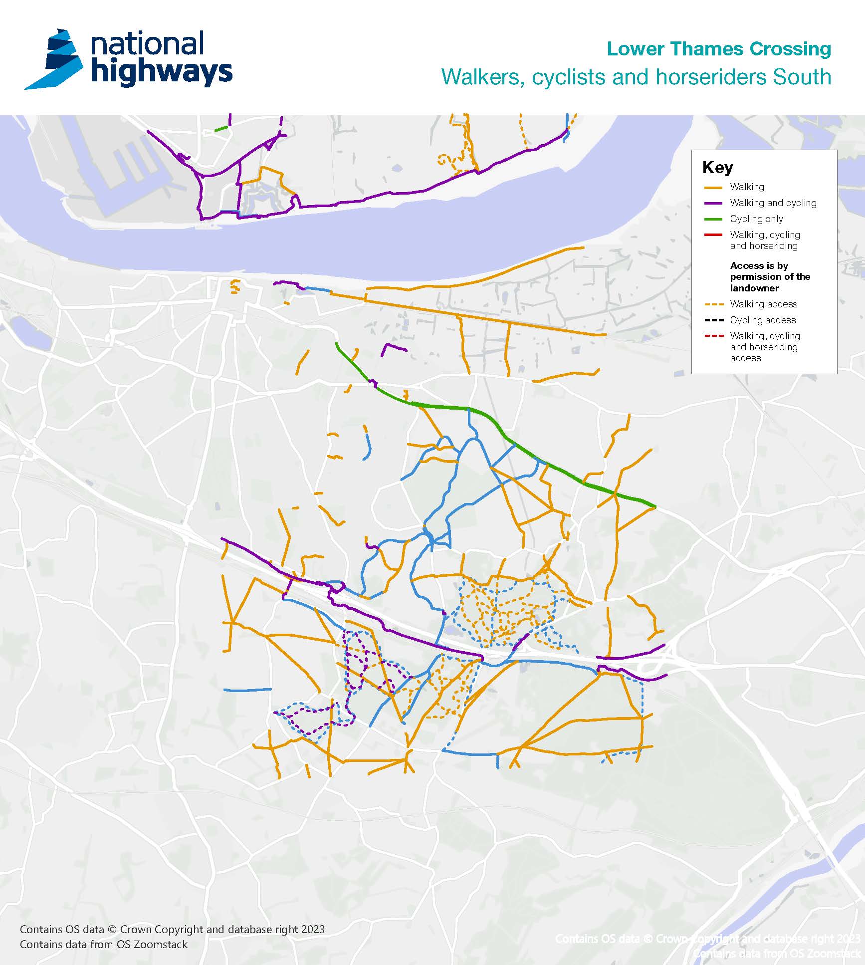
Walkers, cyclists and horse riders in Kent
Over 12 miles of new or improved pathways
In Kent, we are creating new pathways and bridges, as well as improving existing pathways, to offer a combination of shorter looping trails and longer routes.
Connecting this network of pathways to the area’s rich mosaic of parks and woodland are three new green bridges, including an 84m green bridge over Thong Lane – one of the largest in Europe.
Some of the proposals in the Kent area are:
- Three green bridges - over the Lower Thames Crossing and A2 to create safe routes for pedestrians, cyclists, horse riders and wildlife – including an 84m bridge, one of the widest green bridges in Europe
- New and extended foot and cycle paths - connecting residential areas of Gravesend, Rochester, and communities south of the A2, to the parks and woodlands between them
- A new cycle route south of the A2 - running through Jeskyns Community Woodland from Park Pale in the east to Hares bridge in the west
- A network of bridleways - giving horse riders an uninterrupted route through woodlands such as Shorne Woods Country Park and Jeskyns Community woodland
- The creation of the new Chalk Park - a landscaped park that will offer views over the Thames estuary and be crossed with new footpaths that link to the surrounding area.
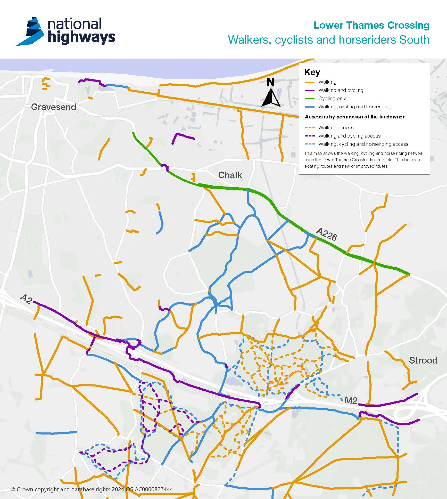
Green bridges – safe and easy connections for people and wildlife
In total, seven new green bridges along the route will provide safe crossing places for people and wildlife, as well as blend the new structures into the landscape.
At the heart of this improved network in Kent will sit three new green bridges – an 84m wide bridge over the new crossing, one of the widest in Europe, and two over the A2.
Thong Lane green bridge over the Lower Thames Crossing
At 84m wide, the Thong Lane green bridge over the Lower Thames Crossing will be the widest green bridge in the project. It will be built to include a segregated bridleway that accommodates horse riders, as well as walkers and cyclists.
From here pathways will lead:
• north towards Chalk Park and Gravesend Road
• east toward Brummelhill Wood via Shorne Ifield Road
• south on a new route that passes between Thong village and the project
Thong Lane green bridge over the A2
At the southern end of Thong Lane, we will replace the existing bridge over the A2 with a new green bridge.
On the eastern side of the bridge we will include walking, cycling and horse-riding provision which will link to a crossing point over the new connector road south of the A2.
From here you can either:
- use the existing green bridge over the railway line to reach Jeskyns Community Woodland, or;
- join the pedestrian-cycle route running on the south side of the connector road west toward the Gravesend East Junction or east to Brewers Road.
Footpaths - creating new journeys
In north Kent there is a well-established network of footpaths, cycle paths and bridleways that connect Gravesend to Thong village, Shorne Woods Country Park and Shorne village.
Where the new crossing heads toward the tunnel under the River Thames, some of these paths will be affected. Rather than recreate these links with underpasses and ramps, we will build a series of new paths and bridleways that maintain existing connections and offer you the choice of quick trips or longer trails. These new journeys will better connect you to the rich mosaic of parks and woodlands that lay between Gravesend and Strood.
NG8 diverted west and upgraded to bridleway
One of the well-used footpaths affected by the project is the NG8 pathway. Found north of Thong Lane, the project would cross diagonally over its current alignment. To keep this footpath up and running, the NG8 will be diverted west, past the eastern edge of Chalk Park, and around the tunnel entrance to meet the existing alignment east of the tunnel portal.
The new diversions to NG8 will be made into bridleway, creating an accessible pathway for pedestrians, cyclists, and horse riders. A series of new paths will be created throughout Chalk Park that links to Thong Lane, further connecting the community to more green spaces.
The remaining northern section of the NG8 footpath, which links up to Lower Higham Road via Church Lane and the A226 Gravesend Road, would be upgraded to bridleway status. This provides all three user types wider east-west connectivity. It will also improve access to the existing east-west connectivity along Lower Higham Road.
NG9 upgraded to bridleway
As you reach the end of the NG8 diversion, the NG9 footpath will also be upgraded to bridleway. This upgrade will continue to where it terminates at the alignment of a new bridleway connecting the A226 Gravesend Road to Shorne Ifield road and Thong Lane.
NS167 and NS174 realigned early in the construction period
To maintain a connection between Thong and the eastern edge of Gravesend, the NS167 and NS174 pathways will be realigned onto two new pathways (a bridleway and a footpath) and will be available early in the construction period. These two new pathways will cross the NS169 pathway, forming two small loops for those wanting a shorter walk.
NG17 diverted north
The eastern end of the NG17 footpath will be diverted north along the urban edge of Gravesend, crossing NS169 and continuing north to the new bridge at Thong Lane.
Have your say - a change has been proposed to this route following feedback received during our consultation in 2021. You will have the opportunity to give feedback on these and other changes in a consultation being planned later in the spring.
NS169 redesigned as pedestrian-cycle track
A short section of NS169 will be changed from footpath to pedestrian-cycle track, to allow cycling between Fairfields/Michael Gardens Play Area and the new bridleway running between the eastern end of NG17 and the new bridge at Thong Lane.
Bridleways – an improved network for horse riders
We are also creating an almost entirely new network of bridleways in this area. Together with the project’s new green bridges, horse riders can enjoy a longer uninterrupted route through the surrounding woodlands and parks. This includes the new Chalk Park and Shorne Woods Country Park.
The Thong Lane green bridge over the A2 will also include a new Pegasus crossing – designed specifically for horse riders, one of many new controlled crossing points being installed to make
passing the new and existing roads safer.
These improvements will create improved connections north and south of the A2, between Shorne Woods Country Park, Ashenbank Woodland and Jeskyns Community Woodland.
Brewers Road existing track improvements
The existing length of shared pedestrian-cycle track on Brewers Road will be opened to horse riders as well and extended to link with a bridleway connecting to Park Pale and the Darnley Trail route, which will allows horse riding. The bridleway will run along existing footpath NS179, which will be upgraded and given bridleway status.
Off-road connection with NS179
A shared pedestrian-cycle-equestrian route would be formed south-west of Park Pale bridge and parallel with the railway line, along the route of existing footpath NS179. To create this route, the existing NS179 would be resurfaced and designated as a bridleway.
The route would provide an off-road connection with NCR 177 and the Darnley Trail route heading east. To the west, a new connection into a shared pedestrian-cycle-equestrian track along Brewers Road would be formed to the south of Brewers Road green bridge; this would also have bridleway status. The route would also connect to the section of NS179 heading south-west to Halfpence Lane, which would remain a footpath.
NCR 177 would follow this route once the Project is built. Park Pale Lane to the north of the A2 would also be available for cyclists as a link between Park Pale bridge and Brewers Road. This would provide an alternative route for those not wanting to use the upgraded NS179 through a woodland area.
Equestrian link from Valley Drive to Thong Lane
The NG17 pathway from Valley Drive will be upgraded to bridleway. The eastern end of NG17 will be diverted north along the urban edge of Gravesend where it will cross NS169 and continue north to the new bridge at Thong Lane.
This route will have bridleway status allowing horse riders a link from Valley Drive to Thong Lane
Upgrade of Hever Court Road to Valley Drive route
Following discussions with the British Horse Society the project has chosen to upgrade the section of pedestrian-cycle route connecting Hever Court Road to Valley Drive to allow horse riders.
This change will give horse riders a better connection between the permissive bridleway parallel to NCR177 and the upgraded NG17 (to be upgraded to a bridleway) also improving connectivity to newly created routes that connect to Chalk Park.
Cycle paths – keeping you on track and a new scenic route
We will be improving connections to the surrounding Kent countryside and country parks or areas of employment, education, and leisure.
Scenic diversion of the NCR 177 route during construction
Our work on a new junction between the A2/M2 and Lower Thames Crossing will sever National Cycle Route NCR 177 that connects Rochester and Gravesend. NCR 177 will be permanently rerouted south of the A2 (parallel with the High Speed 1 railway line), between a point close to Park Pale bridge (near Shorne) and Valley Drive (Gravesend).
Whilst we build the new permanent route of NCR 177, we will open an alternative route that runs south of the A2. This alternative route will be a more scenic journey to the south of the railway line from a point close to Park Pale bridge in the east to Hares bridge in the west, through Ashenbank Wood and Jeskyns Community Woodland.
Rerouting of NCR 177 Route
NCR 177 will be permanently rerouted south of the A2 (parallel with the High Speed 1 railway line), between a point close to Park Pale bridge (near Shorne) and Valley Drive (Gravesend). Once construction of the project is complete, NCR 177 will follow a shared pedestrian-cycle-equestrian route (upgraded NS179) parallel with the railway line, then a shared pedestrian-cycle-equestrian track along Brewers Road, and a new off-road shared pedestrian-cycle track from Halfpence Lane roundabout to the junction at Gravesend East (Valley Drive). At either end, it will connect into the existing NCR 177 alignment. Park Pale Lane to the north of the A2 would also be available for cyclists as a link between Park Pale bridge and Brewers Road.
There will also be a crossing to allow access to the shared track over the Thong Lane replacement green bridge. "This will allow access to other new routes., including a route that passes between Thong village and the project.
NG17 given bridleway status and diverted north
To provide access for cyclists to areas around the junction, NG17 will be given bridleway status and diverted north, while the western part of NS169 will be made available for cyclists.
These changes will give cyclists access from the east of Gravesend to the Claylane Wood, newly planted areas, and to new routes north of Thong Lane.
The diverted NG17 will cross NS169 and continue north to reach the new green bridge at Thong Lane where cycle users will have a number of routes available to them.
New shared pedestrian-cycle-equestrian track along Brewers Road
Alongside Brewers Road there would be a new section of shared pedestrian-cycle-equestrian track. This would connect into the existing track ending at Halfpence roundabout, which track would be widened to meet current standards.
To the west of the Halfpence Lane roundabout there is an existing track along the northern edge of Ashenbank Wood that links to the south side of the existing green bridge over the railway line. The surface of this track would be upgraded for use by pedestrians, cyclists and horse riders. A new off-road shared pedestrian-cycle track would also be provided between Halfpence Lane roundabout and the junction at Gravesend East (Valley Drive).
Improvements to NS195 and NS311 byways
During construction, we will open an alternative route for NCR 177 that runs south of the A2. To create this alternative route, a length of the NS195 and NS311 byways will be improved, bringing the route south of Scalers Hill Stables. From here the alternative route would continue along a combination of new and existing pathways through Jeskyns Community Woodland to reach Henhurst Road, near the existing car park and junction with Church Road.
New woodland planting and bridleway near Church Lane
There would be an area of woodland mitigation planting to the south of Church Lane, and a new bridleway would be formed through the northern fringe of this area. This will provide an off-road route parallel to Church Road as far as footpath NS175A. During construction, the alternative route for NCR 177 would follow this off-road route.
The NS175A pathway south of the bridge over the railway line and between this bridge and the bridge over the A2 (Hares bridge), will have its surface improved and its status would be changed to allow cyclist access (except for the section over the railway bridge, which does not meet requirements for a cycle bridge), and where cyclists would be asked to dismount.
