A417 Missing Link
A landscape-led highways scheme that will deliver a safe and resilient free-flowing road while conserving and enhancing the special character of the Cotswolds National Landscape. Our scheme will improve the connection between two dual carriageway sections of the A417 at Brockworth and Cowley.
Latest updates
-
28 July 2026
Weekend closures
The A417 will be closed in both directions between the A46 Brockworth junction and Air Balloon roundabout from;
- 11pm on Friday 31 July to 6am Monday 3 August
- 11pm on Friday 14 August to 6am Monday 17 August
- 11pm on Friday 21 August to 6am Monday 24 August
These closures are necessary to allow us to:
- divert a water main
- clear vegetation
- and complete surfacing works
Overnight road closures (weeknights only)
The new A436 and A417 will be closed in both directions between the Air Balloon and Ullenwood roundabout and A429 Burford Road overnight:
- 9pm on Monday 27 July to 6am Friday 31 July
- 9pm on Monday 24 August to 6am Friday 28 August
These closures are necessary to allow us to install signage, fencing and communication infrastructure.
The A417 will be closed in both directions between the A46 Brockworth junction and Air Balloon roundabout overnight:
- 9pm on Monday 17 August to 6am Friday 21 August
Diversion route
Fully signed diversion routes will be in place during the closure. Please follow the official, signed diversion route and not satnavs.
Access for emergency services will be fully maintained during the closures.
We currently have a temporary route in place on the A417.
A417 closure and diversion route map
Air Balloon to A429 Burford closure and diversion map
A446 Brockworth junction to Air Balloon closure and diversion mapThese maps give you more details of the temporary route:
- A417 Missing Link temporary route overview
- Air Balloon and Ullenwood roundabout
- Shab Hill junction
- Cowley junction
- A417 temporary route maps (pdf)
- Cotswold way diversion
Learn more about the temporary route.
-
08 July 2026
A417 Missing Link reaches major milestone
We reached a major milestone this week as the first vehicles travelled on a new section of the A346 and A417.
We've permanently closed the existing A417 between Air Balloon and the B4070.
Expect delays, particularly at peak times. Plan ahead and allow extra time for their journeys.
The temporary route will be in place until September.
These maps give you more details of the temporary route:
A417 Missing Link temporary route overview
Air Balloon and Ullenwood roundabout
Shab Hill junction
Cowley junction
A417 temporary route maps (pdf)Learn more about the temporary route.
-
09 June 2026
Work in June and new temporary route from summer
Monday 8 to Thursday 11 June - A417 in both directions between A46 Brockworth junction and Air Balloon roundabout
Closed overnight (9pm - 6am). Last closure lifted 6am Thursday 11 June.
Diversion route for A46 Brockworth Junction
From 9pm on Monday 15 June to 6am Thursday 18 June - The A436 in both directions between Air Balloon roundabout and Seven Springs roundabout
Closed overnight (9pm - 6am). Last closure lifted 6am Thursday 15 June.
Diversion route for Air Balloon to Seven Springs
Please follow signed diversion routes and not satnavs.
We'll maintain access for emergency services
New temporary route - summer 2026
This summer, we'll move traffic to a temporary route on the A417 between:
- A46 Brockworth interchange
- the former Cowley roundabout.
This allows us to work in new areas and finish constructing the road.
These maps give you more details:
A417 Missing Link temporary route overview
Air Balloon and Ullenwood roundabout
Shab Hill junction
Cowley junctionWe'll open the new section of the A436 and A417 to traffic from 6am Monday 29 June. We expect it to be in place for at least five weeks.
The road will look and feel different:
- it will have narrower lanes and a 40mph speed limit
- the A417 will be reduced to one lane in both directions between A46 Brockworth Junction and Air Balloon roundabout
Switching traffic to this new section lets us keep the road open, protect our workers and minimise disruption. It's a key milestone, which includes permanently closing the existing A417 between Air Balloon and the existing B4070.
Expect delays
We expect this work to cause significant delays in the area.
Please plan your journeys in advance and allow extra time.
If you use the A417 as part of a longer journey, consider alternative roads where possible - especially in peak times.
Closures
To prepare the temporary route, we'll need these closures:
Thursday 25 June - A417 in both directions between A46 Brockworth junction and the Air Balloon roundabout
Closed overnight (9pm - 6am).
Diversion route for A46 Brockworth Junction
9pm Friday 26 to 6am Monday 29 June - A417 in both directions between the A429 Burford Road and the Air Balloon roundabout
Weekend closure.
A429 Burford Road and the Air Balloon roundabout diversion map.
Please follow signed diversion routes and not sat navs.
Please remember that closures can change at short notice. You can check the latest information on our daily closures page or find live travel information on our Traffic England. Our travel alerts give details of live incidents on our network.
-
06 May 2026
Upcoming closures
We're undertaking weekend and overnight closures during April and May, which may affect journeys in the area.
A417 Weeknight closures
The A417 will be closed in both directions between the A46 Brockworth junction and the Air Balloon roundabout overnight from:
- 9pm on Tuesday 5 May to 6am on Saturday 9 May
- 9pm on Monday 11 May to 6am on Saturday 16 May
- 9pm on Tuesday 26 May to 6am on Sunday 31 May
The road will be open in the daytime as normal
These closures are required to allow us to carry out earthworks, surfacing, drainage works and central barrier construction so that traffic can be moved onto the new A417. They will generate noise, which we'll monitor each night.
We'll maintain access for emergency services during the closures.
Fully signposted diversion routes will be in place during the closure.
Please follow the official, signed diversion route and not satnavs.
Diversions
Brockworth junction to Air Balloon roundabout southbound diversion:
- turn left towards Cheltenham onto the A46 Shurdington Road
- turn right towards Oxford onto the A40 Thirlestaine Road
- turn right towards Cirencester onto London Road
- continue towards Cirencester on the A435
- turn right on the Seven Springs roundabout onto the A436 and continue towards the Air Balloon Roundabout
Air Balloon roundabout to Brockworth junction northbound diversion:
- turn right at the Air Balloon Roundabout, follow the A436 towards Seven Springs
- from Seven Springs roundabout, follow Cirencester road towards Cheltenham
- continue on the A435 and turn left towards Cheltenham onto the A40
- turn left onto the A40 Old Bath Road
- follow the road to the right and remain on the A40
- turn left onto the A46 Shurdington Road
- take the third turning at Brockworth junction to travel towards Gloucester
Public information events
We are holding two information events on site to update you on the scheme. Feel free to drop by with no appointment. These will be held on the following dates:
Tuesday 26 May – 3pm – 8pm
Wednesday 27 May – 2pm – 7pmOur address is A417 Crusher Compound, Birdlip, Gloucester, GL4 8JX. You can also use What3words: ///shaped.quietest.payback.
Please remember that closures can change at short notice. You can check the latest information on our daily closures page or find live travel information on our Traffic England. Our travel alerts give details of live incidents on our network.
-
20 February 2026
A417 Missing Link – Upcoming closures
There will be weekend and overnight closures during February and March, which may affect journeys in the area:
16 February to 13 March A417 weeknight closures (9pm-6am)
- the A417 will be closed in both directions between the A46 Brockworth junction and the Air Balloon roundabout overnight (Monday to Friday)
- Friday 6 March the A417 will be open as normal
The road will be open in the daytime as normal.
Access for traffic travelling towards Cirencester by the A417, Leckhampton Hill, and the A436 will remain open by the Air Balloon roundabout, including entry to Crickley Hill Country Park.
There is no pedestrian access between the A46 Brockworth junction and the Air Balloon roundabout during these overnight closures, and no other walking routes are affected.
We’ll be carrying out earthworks, drainage and surfacing works to prepare for traffic to be moved onto the new A417.
These activities may generate noise, which we will monitor each night.
A436 Weekend closures
The A436 will be closed in both directions between the Air Balloon roundabout and the Seven Springs roundabout:
- from 9pm on Friday 20 March to 6am Monday 23 March
16 March to 20 March A417 weeknight closures (9pm-6am)
The A417 will be closed in both directions between the Air Balloon roundabout and A429 Burford road overnight, Monday to Friday.
The road will be open in the daytime as normal.
The road closure is scheduled to finish at 6am on Saturday 21 March.
This work is required to complete essential utility diversions, pavement works, and earthworks.
Please note that these works can change due to weather conditions or unforeseen circumstances.
Access for emergency services will be fully maintained during the closures.
Fully signposted diversion routes will be in place during the closure.
Please follow the official, signed diversion route and not satnav.
Diversions
Air Balloon roundabout to Brockworth junction northbound diversion:
- turn right at the Air Balloon Roundabout, follow the A436 towards Seven Springs
- from Seven Springs roundabout, follow Cirencester road towards Cheltenham
- continue on the A435 and turn left towards Cheltenham onto the A40
- turn left onto the A40 Old Bath Road
- follow the road to the right and remain on the A40
- turn left onto the A46 Shurdington Road
- take the third turning at Brockworth junction to travel towards Gloucester
Brockworth junction to Air Balloon roundabout southbound diversion:
- turn left towards Cheltenham onto the A46 Shurdington Road
- turn right towards Oxford onto the A40 Thirlestaine Road
- turn right towards Cirencester onto London Road
- continue towards Cirencester on the A435
- turn right on the Seven Springs roundabout onto the A436
- continue towards Cirencester on the A417
- turn left towards Cirencester onto the A417
A417 Air Balloon roundabout to Brockworth junction diversion map
Air Balloon to Burford Road northbound diversion:
- turn right onto the A429 Burford Road
- turn left and follow the A429 towards Stow-on-the-Wold
- turn left and follow the A40 towards Cheltenham
- turn left and follow the A436 towards Gloucester
- head over the roundabout towards Gloucester
Air Balloon to Burford Road southbound diversion:
- follow A436 towards Stow-on-the-Wold
- turn left at the Severn Springs roundabout
- then turn right onto the A436 Oxford Road
- turn right towards Oxford and follow the A40
- turn right towards Cirencester onto the A429
A417 Burford Road to Air Balloon diversion map
Air Balloon Roundabout to Seven Springs eastbound diversion:
- follow the A417 towards Gloucester
- turn right towards Cheltenham onto the A46 Shurdington Road
- turn right onto the A40 towards Oxford
- turn right towards Cirencester
- turn right onto the A435 Cirencester Road
Air Balloon Roundabout to Seven Springs westbound diversion:
- continue on the A436 towards Cheltenham
- turn left onto the A40 London Road
- turn left towards Gloucester
- turn left towards Gloucester onto the A40 Bath Road
- turn left onto the A46 Shurdington Road
A436 Air Balloon to Seven Springs diversion map
Please remember that closures can change at short notice. You can check the latest information on our daily closures page or find live travel information on our Traffic England site. Our travel alerts give details of live incidents on our network.
-
10 December 2025
Christmas and New Year update
We have no planned road closures on the A417 Missing Link project in December 2025.
This doesn't include emergency closures. You can check for details of incidents on our network on our Travel alerts page.
We'll give you information of planned road closures in 2026 on this page when we have firm details.
Watch a video of our progress in 2025.
We'll close the customer hub at the Crusher Compound from Wednesday 17 December until Tuesday 13 January.
-
22 September 2025
Work from 22 September - October
22 to 27 September - Leckhampton Hill closure
We're closing Leckhampton Hill between the Air Balloon roundabout and Ullenwood Manor Road overnight from Monday 22 until Saturday 27 September (9pm to 6am).
These overnight closures are needed to allow us to finish the entrance to Crickley Hill Country Park.
Diversion signs will be in place to guide drivers along the diversion route by Seven Springs.
The A436 and A417 will remain open to traffic as normal.
29 September to 4 October - A417 overnight closures
We'll close the A417 between A46 Brockworth junction and Air Balloon roundabout overnight (9pm - 6am) from Monday 29 September to Saturday 4 October.
We need the closures for surveys, traffic management and utility works.
Access between the A417 Leckhampton Hill and the A436 by the Air Balloon Roundabout will remain open. This includes entry to Crickley Hill Country Park.
We'll put traffic signals on Air Balloon roundabout. Please drive carefully and use signed diversion routes during closures.
Please remember that closures can change at short notice. You can check the latest information on our daily closures page or find live travel information on our Traffic England. Our travel alerts give details of live incidents on our network.
-
04 September 2025
A417 Missing Link – Full weekend closure cancellation 12 to 15 September
We've postponed the weekend closure scheduled for Friday 12 September to Monday 15 September due to the weather forecast.
Unfortunately, these circumstances are beyond our control. We need to make sure conditions are right for us to work safely and effectively.
Please remember that closures can change at short notice. You can check the latest information on our daily closures page or find live travel information on our Traffic England. Our travel alerts give details of live incidents on our network.
-
29 August 2025
29 August - 1 September weekend closure postponed
Due to bad weather forecasts, we've postponed the weekend closure scheduled for Friday 29 August to 1 September.
Unfortunately, these circumstances are beyond our control. We need to make sure conditions are right for us to work safely and effectively, so we've rescheduled the closure.
Weekend A417 closure rescheduled for 9pm Friday 12 to 6am Monday 15 September
We'll close the A417 between the Air Balloon Roundabout and the A429 Burford Road.
Over the weekend we'll be:
- constructing utility ducting
- realigning and surfacing sections of road
- starting to build the new Cowley roundabout.
We'll put fully signposted diversion routes in place during the closure.
Please follow the official diversion route. Don't follow satnav instructions - they may not show you the most appropriate alternative routes during roadworks.
We'll maintain access for emergency services during the closure.
Please remember that closures can change at short notice. You can check the latest information on our daily closures page or find live travel information on our Traffic England site. Our travel alerts give details of live incidents on our network.
-
18 July 2025
A417 road closures
We're carrying out essential improvement works on the A417 this summer. We know these dates fall during the busy holiday period, so please plan your journey in advance and check your route to avoid delays.
Weekend closures
The A417 will be closed between the Air Balloon Roundabout and the A429 Burford Road junction from:
- 11pm on Friday 25 July to 6am on Monday 28 July
- 11pm on Friday 1 August to 6am on Monday 4 August
- 11pm on Friday 29 August to 6am on Monday 1 September
These closures are necessary to allow us to:
- construct utility ducting
- realign sections of the road
- carry out essential surfacing works
- begin construction of the new Cowley Roundabout
We understand that some noise from these works could potentially be heard from nearby properties, and we'd like to apologise in advance for any inconvenience this may cause.
Fully signposted diversion routes will be in place during the closure.
Please follow the official diversion route and not satnavs, as these may not show the most appropriate alternative routes during roadworks.
Access for emergency services will be fully maintained during the closures.
Barrow Wake car park closure
Please remember that Barrow Wake viewpoint car park will remain closed until Spring 2027. This is so that we can build a new dry-stone wall to stop glare from vehicle lights. We're also installing drainage tanks under the carriageway.
Local businesses will remain open as normal.
-
13 June 2025
Closures in June and July
A417 - A46 Brockworth junction to the Air Balloon roundabout
The A417 will be closed between the A46 Brockworth junction and the Air Balloon roundabout:
- 9pm on Saturday 21 June to 6am Monday 23 June
- Overnight Sunday 29 June to Friday 4 July between 9pm and 6am
- 11pm on Friday 4 July to 6am Monday 7 July
These closures are required while we carry out resurfacing activities, white lining and install vehicle restraint systems.
We understand that some noise from these works could potentially be heard from nearby properties, and we’d like to apologise in advance for any inconvenience this may cause.
Access between the A417, Leckhampton Hill, and the A436 via the Air Balloon Roundabout will remain open, including entry to Crickley Hill Country Park.
Access for emergency services will be fully maintained during the closures.
Diversion
For the southbound diversion - Brockworth junction to Air Balloon roundabout:
- Turn left towards Cheltenham onto the A46 Shurdington Road.
- Turn right towards Oxford onto the A40 Thirlestaine Road.
- Turn right towards Cirencester onto the A40 Old bath Road.
- Turn right towards Cirencester on the A435.
- Turn right on the Seven Springs roundabout onto the A436.
- Continue towards Cirencester on the A417.
- Turn left towards Cirencester onto the A417.
For the northbound diversion - Air Balloon roundabout to Brockworth junction:
- Turn right at the Air Balloon Roundabout, follow the A436 towards Seven Springs.
- From Seven Springs roundabout, follow Cirencester road towards Cheltenham.
- Continue on the A435 and turn left towards Cheltenham onto the A40.
- Turn left onto the A40 Old Bath Road.
- Follow the road to the right and remain on the A40.
- Turn left onto the A46 Shurdington Road.
- Take the third turning at Brockworth junction to travel towards Gloucester.
B4070 closure
The B4070 will be closed between Birdlip Village and the access to Barrow Wake viewpoint for two nights:
- Tuesday 24 June and Wednesday 25 June, between 9pm and 6am
This closure is required to allow for vegetation clearance and the installation of drainage and utilities.
The B4070 will remain open on the section of road outside The Royal George pub, Birdlip Hill and continuing onto Cirencester Road.
Our traffic management team will be positioned at both ends of the road closure and will be available to escort residents who live within the closure area only.
We understand that some noise from these works could potentially be heard from nearby properties, and we’d like to apologise in advance for any inconvenience this may cause.
Diversion
A417 to Birdlip:
- Follow the A417 Northbound to the Air Balloon Roundabout.
- At the roundabout, turn left and continue down the hill on the
- A417 towards the A46 Brockworth Junction.
- At Brockworth Junction, turn left onto the A46 Shurdington Road.
- At Cross Hands Roundabout, turn left onto Cirencester Road.
Turn right onto Ermin Way and continue towards Birdlip Hill.
Birdlip to A417:
- Travel down Birdlip Hill onto Ermin Way, then turn left onto Cirencester Road.
- At Cross Hands Roundabout, turn right onto the A46 Shurdington Road.
- At the A46 Brockworth Junction, turn right onto the A417 and travel up the hill.
- At the Air Balloon Roundabout, turn right to continue on the A417.
A417 - the Highwayman Inn to the A429
The A417 will be closed between the Highwayman Inn and the A429 Burford Road junction (southbound):
- Thursday 26 June between 9pm and 6am
Diversion
Air Balloon to A429 Burford Road Southbound:
- Follow A436 towards Stow-on-the-Wold
- Turn left towards the Seven Springs roundabout
- At Seven Springs Roundabout, turn left and then right onto the A436 Oxford Road
- Turn right towards Oxford and follow the A40
- Turn right towards Cirencester onto the A429
Please follow the official diversion routes.
Access for emergency services will be fully maintained during the closures.
-
19 May 2025
Weekend closure
The A417 will be closed between the A46 Brockworth junction and the Air Balloon roundabout for a full weekend from 11pm on Friday 30 May to 6am on Monday 2 June.
The closure is required while we remove and reinstate kerbs, verges, install drainage and carry out resurfacing activities as part of the A417 Missing Link scheme.
We understand that some noise from these works could potentially be heard from nearby properties, and we’d like to apologise in advance for any inconvenience this may cause.
Access between the A417, Leckhampton Hill, and the A436 via the Air Balloon Roundabout will remain open, including entry to Crickley Hill Country Park.
Fully signposted diversion routes will be in place during the closure. Please follow the official diversion route not satnavs.
Diversions
For the southbound diversion - Brockworth junction to Air Balloon roundabout:
- turn left towards Cheltenham onto the A46 Shurdington Road
- turn right towards Oxford onto the A40 Thirlestaine Road
- turn right towards Cirencester onto the A40 Old bath Road
- turn right towards Cirencester on the A435
- turn right on the Seven Springs roundabout onto the A436
- continue towards Cirencester on the A417
- turn left towards Cirencester onto the A417
For the northbound diversion - Air Balloon roundabout to Brockworth junction:
- turn right at the Air Balloon Roundabout, follow the A436 towards Seven Springs
- from Seven Springs roundabout, follow Cirencester road towards Cheltenham
- continue on the A435 and turn left towards Cheltenham onto the A40
- turn left onto the A40 Old Bath Road
- follow the road to the right and remain on the A40
- turn left onto the A46 Shurdington Road
- take the third turning at Brockworth junction to travel towards Gloucester
-
30 April 2025
A417 overnight closures
We'll close the A417 overnight (9pm to 6am) between the A46 Brockworth junction and the Air Balloon roundabout from:
Monday 12 May to Friday 16 May
We need this closure to remove and reinstate kerbs, verges, install drainage and carry out resurfacing activities.
Please follow the official diversion route and not satnavs.
Southbound diversion - Brockworth junction to Air Balloon roundabout:
- turn left towards Cheltenham onto the A46 Shurdington Road
- turn right towards Oxford onto the A40 Thirlestaine Road
- turn right towards Cirencester onto the A40 Old Bath Road
- turn right towards Cirencester on the A345
- turn right on the Seven Springs roundabout onto the A436
- continue towards Cirencester on the A417
Northbound diversion - Air Balloon roundabout to Brockworth junction:
- turn right at the Air Balloon Roundabout, follow the A436 towards Seven Springs
- from Seven Springs roundabout, follow Cirencester road towards Cheltenham
- continue on the A435 and turn left towards Cheltenham onto the A40
- turn left onto the A40 Old Bath Road
- follow the road to the right and remain on the A40
- turn left onto the A46 Shurdington Road
- take the third turning at Brockworth junction to travel towards Gloucester
-
11 April 2025
Overnight closures between A46 Brockworth junction and the Air Balloon roundabout
We’ll close the A417 overnight (9pm to 6am) between the A46 Brockworth junction and the Air Balloon roundabout on:
- Thursday 24 April to Friday 25 April
We need this closure to carry out surfacing activities.
The A436, Leckhampton Hill and the A417 towards Cirencester, will be accessible from the Air Balloon Roundabout under temporary traffic lights.
Please follow the official diversion route and not satnavs.
Southbound diversion - Brockworth junction to Air Balloon roundabout:
- turn left towards Cheltenham onto the A46 Shurdington Road
- turn right towards Oxford onto the A40 Thirlestaine Road
- turn right towards Cirencester onto the A40 Old bath Road
- turn right towards Cirencester on the A345
- turn right on the Seven Springs roundabout onto the A436
- continue towards Cirencester on the A417
Northbound diversion - Air Balloon roundabout to Brockworth junction:
- from Seven Springs roundabout, follow Cirencester road towards Cheltenham
- continue on the A435 and turn left towards Cheltenham onto the A40
- turn left onto the A40 Old Bath Road
- follow the road to the right and remain on the A40
- turn left onto the A46 Shurdington Road
- take the third turning at Brockworth junction to travel towards Gloucester
-
02 April 2025
Cirencester Road closure
We need to install drainage along Cirencester Road in Witcombe and to carry out this work safely we will need evening road closures.
Cirencester Road will be closed between Dog Lane and Green Lane from Monday 7 April to Friday 18 April, between the hours of 5pm to midnight.
During the day, one side of the carriageway will remain closed, and the road will operate under two-way lights.
Once the work is complete, the carriageway will fully reopen at 11:45 pm on Friday 18 April.
Fully signposted diversion routes will be in place during the closure.
Please follow the official diversion route and not satnavs.
Witcombe residents on the western side of the A417, will not be able to travel under the bridge via Cirencester Road during the road closure.
-
12 March 2025
Mid-week lane closures at Air Balloon Roundabout and weekend closure on the A436
There will be mid-week lane closures at the Air Balloon Roundabout and a weekend closure on the A436 this month while we carry out road surfacing activities.
Overnight lane closure:
We will be closing one lane for eastbound traffic travelling from the Air Balloon roundabout onto the A436.
This closure will take place overnight only between the hours of 9pm and 6am from Monday 24 March to Thursday 27 March.
We will be keeping one lane open for traffic travelling westbound from the A436 towards the Air Balloon roundabout.
Weekend closure:
The A436 will be closed between the Air Balloon roundabout and the Seven Springs roundabout between 9pm on Friday 28 March and 6am on Monday 31 March.
During the mid-week closure and the weekend closure:
- The A436 and the top of Leckhampton Hill will be closed.
- Access to Crickley Hill Country Park will be available via the closure point on Leckhampton Hill.
- The Air Balloon roundabout will continue to be open for all traffic travelling between the A46 Brockworth junction and the A417.
Fully signposted diversion routes will be in place during the closures. Please follow the official diversion route and not satnavs.
-
25 February 2025
A417 overnight closures in March
We'll close the A417 overnight (9pm to 6am) between the Air Balloon roundabout and Burford Road junction on these dates:
- Wednesday 5 March to Thursday 6 March
- Thursday 6 March to Friday 7 March
We need these closures to remove lighting columns safely.
We'll put fully signposted diversion routes in place during the closure.
-
29 January 2025
A436 overnight closures
The A436 will be closed between the Air Balloon roundabout and the Seven Springs roundabout overnight on the following dates:
- 9pm on Thursday 6 February to 6am on Friday 7 February
- 9pm on Friday 7 February to 6am on Saturday 8 February
Due to recent weather conditions, we will be bringing forward our work to install permanent drainage in this area to prevent flooding.
We apologise for the short notice of this closure caused by the change in schedule.
We have taken measures to reduce disruption where possible. Thank you for your patience and understanding during this time.
Fully signposted diversion routes will be in place during the closure.
Please follow the official diversion route and not satnavs.
Eastbound diversion - Air Balloon to Seven Springs
- Follow the A417 towards Gloucester
- Turn right towards Cheltenham onto the A46 Shurdington Road
- Turn right onto the A40 towards Oxford
- Turn right towards Cirencester
- Turn right onto the A435 Cirencester Road
Westbound diversion - Air Balloon to Seven Springs
- Continue on the A436 towards Cheltenham
- Turn left onto the A40 London Road
- Turn left towards Gloucester
- Turn left towards Gloucester onto the A40 Bath Road
- Turn left onto the A46 Shurdington Road
Access for residents and emergency services will be fully maintained during the closures.
If you have any questions, or you would like to speak to someone about this work, you can call our contact centre on 0300 123 5000, who will pass your details to the team, or email a417missinglinkatairballoon@nationalhighways.co.uk.
-
27 January 2025
A417 weekend closures
The A417 will be closed between the A46 Brockworth junction and the Air Balloon roundabout for two full weekends on the following dates:
- 11pm on Friday 21 February to 6am on Monday 24 February
- 11pm on Friday 7 March to 6am on Monday 10 March
The closures are needed so we can install drainage and utilities.
Fully signposted diversion routes will be in place. Please follow the official diversion route and not satnavs.Access for residents with permits and emergency services will be maintained during the closures.
We’re here to help during weekend closures with a 24-hour contact number 07751742091. Feel free to text us any questions, and we’ll respond within an hour.
Diversions
For the southbound diversion - Brockworth junction to Air Balloon roundabout:
- turn left towards Cheltenham onto the A46 Shurdington Road
- turn right towards Oxford onto the A40 Thirlestaine Road
- turn right towards Cirencester onto the A40 Old bath Road
- turn right towards Cirencester on the A345
- continue straight towards Birdlip
- turn right on the Seven Springs roundabout onto the A436
- turn left towards Cirencester onto the A417
For the northbound diversion - Air Balloon roundabout to Brockworth junction:
- from Seven Springs roundabout, follow Cirencester road towards Cheltenham
- continue on the A435 and turn left towards Cheltenham onto the A40
- turn left onto the A40 Old Bath Road
- follow the road to the right and remain on the A40
- turn left onto the A46 Shurdington Road
- take the third turning at Brockworth junction to travel towards Gloucester
If you have any questions, or you would like to speak to someone about this work, you can call our contact centre on 0300 123 5000 or email a417missinglinkatairballoon@nationalhighways.co.uk.
-
17 December 2024
Construction round up 2024
Take a look at the progress that has been made on the A417 Missing Link project this year in our video below.
-
31 January 2024
A look ahead to 2024
This January, we’ve been continuing with our preliminary works. As well as building a new site entrance close to the Air Balloon roundabout, we’ve been busy widening a section of carriageway on the A417 so that we can keep traffic moving more smoothly during the next phase of construction.
In April, we'll be ready to start building the new section of the A417. This section is to the south and east of the Air Balloon roundabout and is referred to as ‘offline’ as it is away from the existing road network.
Connecting Parishes
Improving connectivity doesn’t just apply to the road! Connecting Parishes is a project that National Highways is working on, together with Gloucestershire County Council and the Gloucestershire Local Access Forum, to improve connectivity and accessibility of the Public Rights of Way (PRoW) near the A417.
How is the project being funded?
This project has received Designated Funding from National Highways’ ‘Users and Communities’ fund, which aligns with the ‘Walkers, Cyclists and Horse Riders and Communities’ themes. The purpose of these funding streams is to build new infrastructure and enhance existing facilities to encourage sustainable, non-motorised forms of transport.
What is Connecting Parishes?
The Connecting Parishes project seeks to reconnect PRoW between neighbouring parishes and the Cotswolds Way, which were previously severed by the Strategic Road Network.
There will be a core focus on improving active travel, ensuring there are more accessible and safer active travel options which will enhance local connectivity for communities and allow more people to enjoy the Cotswolds National Landscape (formerly known as the Cotswolds Area of Outstanding Natural Beauty).
Working with Gloucestershire County Council, who are leading on delivering these projects, Connecting Parishes consists of 18 different sections of Public Rights of Way which will link into the Air Balloon Way, the Cotswold Way or other promoted routes.
You may have noticed some work has already started. If these works have impacted you, we’d like to thank you for your patience and understanding while we deliver this important project, which will offer many benefits to local people and visitors. We’ll share more updates with you and photos as the project progresses.
-
08 January 2024
Digging for Britain feature
We’ve started off 2024 with some exciting news as the A417 Missing Link project is featured in the new series of Digging for Britain. The eleventh series of the popular TV programme went live on BBC iPlayer on the 2 January and the episode that features the project aired live on the 4 January.
The project features in episode 3 at around 48 minutes in. We hope you enjoy watching it and find it as fascinating as us! This is just a small part of the important preparatory work we’ve been busy doing. You can watch the episode here.
-
21 December 2023
Air Balloon pub demolition complete
As you may have seen, demolition of the Air Balloon pub has now been completed. This was a necessary step to make way for the new A417 Missing Link road, which we will start to build early in the new year.
We understand how many of you value the history of the pub and, recognising that it was named after one of the first British balloon flights, we’re proposing to call a section of the repurposed A417, the Air Balloon Way.
We’re also planning to reuse as much of the building materials as possible and are exploring the possibility of using some of it to create installations and outdoor furniture for the local area that celebrate its cherished history. We already have a local carpenter lined up to make some benches that will eventually be located on the new and improved walking, cycling and horse riding network for all to enjoy.
We’ve started to clear vegetation in preparation for the next phase of construction. All vegetation clearance is being done sensitively, under the watchful eye of an independent arboricultural clerk of works. Site-wide inspections of trees and vegetation, ecological surveys and mitigation to protect trees and local bat populations were done prior to this work commencing. Wherever possible we will be replacing lost vegetation and trees, which will over time help screen the new road and create new habitats and habitat connections for native wildlife to flourish.
-
01 December 2023
Seal of approval paves way for main construction
We’ve been working hard behind the scenes with local authorities and statutory bodies to ensure that planning conditions (requirements), as set out in our Development Consent Order, are met and signed-off (discharged) by the Secretary of State for Transport ahead of main construction.
A key milestone for the project, this task has now been completed and means we can start the main build in early 2024.
As we move towards this next phase you will start to see vegetation clearance along the route, which is being carried out under the watchful eye of a specialist clerk of works.
Secretary of State speaks about the scheme
In this short video, Rt Hon Mark Harper MP talks about the A417 Missing Link project during his recent visit to site. The Secretary of State is joined by Sir Geoffrey Clifton-Brown MP, CEO National Highways Nick Harris, Project Director Kevin Jones and Environmental Laad Kris Atkins.
What’s happening next?
Take a moment to watch this new animation video which explains how we are phasing construction of the A417 Missing Link.
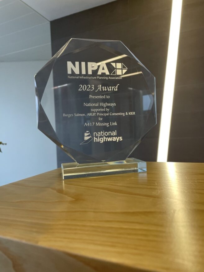
Success as project secures prestigious NIPA award
We’re delighted to share that the A417 Missing Link project has been named winner of the National Infrastructure Planning Association (NIPA) Infrastructure Award 2023. The award recognises best practice for planning, design, development and delivery of Nationally Significant Infrastructure Projects. Commendations were given for “genuinely listening to stakeholders and changing design accordingly”.
The success of this project, through preliminary design, planning and Development Consent, has only been possible thanks to our stakeholders and the collaborative relationships we have with you.
Our shared goal has been to deliver much needed improvements to tackle the long-standing congestion and safety issues on this road, whilst conserving and enhancing the special character of the Cotswolds Area of Outstanding Natural Beauty.
A huge thank you goes to the local MPs, Cotswolds National Landscape, National Trust, Gloucestershire Wildlife Trust, our colleagues at Gloucestershire County Council, Cotswold District Council, Tewkesbury Borough Council, landowners and local communities. Every one of our stakeholders and partners has been key to shaping the scheme and its landscape-led vision.
We will continue to engage, keep you informed and ask for your support as we move through the construction phase.
-
20 September 2023
Supporting UK bat species along the A417 Missing Link
Converting a World War II bunker for wildlife is just one of the innovative measures National Highways is taking to help support UK species of bats that have made their home in Gloucestershire.
The converted structure will be home to the Lesser Horseshoe, Brown Long Eared and other species of bats.
National Highways is also installing bat boxes in suitable habitat across the scheme, which although not obvious to passing motorists, provide vital homes for the bats.
In addition, ecologists will utilise a widely used and accepted tree aging technique for young trees and create roosts that mimics crevices only found on older more mature trees.
Three other bat structures will also be created as part of the scheme, and we will plant trees, hedges, woodland and grasslands to improve their foraging habitats.
To ensure local bat populations are properly supported during the build, we’ve got a team of Ecologists on site at all times to ensure these mitigation measures are implemented correctly.
Work on the scheme goes beyond bats though, with ecologists continuing to relocate reptiles away from construction areas including baby common lizards, slow worms, Roman snails and adders.
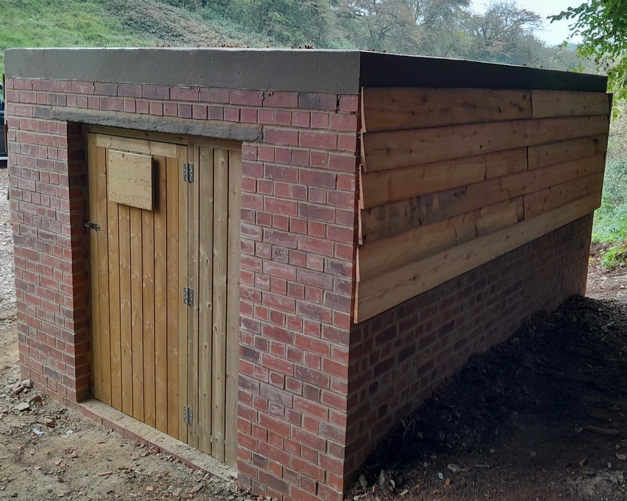
Caption: The converted World War II bunker, which will eventually be covered by vegetation and hidden from sight, is one innovative way National Highways is helping to support bats and wildlife
-
16 November 2022
Scheme gets the go-ahead
We’re delighted that Transport Minister Huw Merriman MP has today approved this landscape-led highways scheme that will deliver a safe and resilient free-flowing road while conserving and enhancing the special character of the Cotswolds Area of Outstanding Natural Beauty.
We would like to thank everyone who has provided feedback and helped shape this vital scheme, which will improve the connection between two dual carriageway sections of the A417 at Brockworth and Cowley, and links between the M4 and M5, making it safer and reducing traffic congestion and the knock-on effect of rat running in local villages.
The Minster’s long-awaited decision means we can now take action to improve this much needed stretch of road. Our Chief Executive, Nick Harris welcomes the news and explains what it means for local people.
To help you visualise the new road, see our latest fly-through animation.
We now enter a six-week judicial review period, but we will continue to work closely with our stakeholders and move this project forward during this time.
You can view the official decision letter, granting the scheme approval, on the Planning Inspectorate's website.
-
29 June 2022
School pupils dig visit from National Highways staff
Our project team and representatives from Cotswold Archaeology took time out to visit Birdlip Primary School, where year 3 and 4 pupils got the chance to chat to the team about their jobs, plans to improve journeys between Brockworth bypass and Cowley roundabout and see what finds have been dug up along the route, which used to be the home to Romans.
One item discussed was an almost 2,000-year-old figurine depicting Cupid, the Roman God of love, which was discovered along with a bow-shaped brooch, and a Roman or early Saxon skeleton.
The items were found along the proposed 3.4 mile stretch of the new A417 Missing Link route and go some way to showing what life in the area was like thousands of years ago.
The Cupid figurine is a rare find, with less than 50 known in the UK, and is one of only three that have been found as part of an archaeological dig as opposed to by metal detectorists.
Made of solid bronze with wings and holding a flaming torch, the figurine was discovered in a deposit of charcoal, suggesting it could be an offering to the Gods.
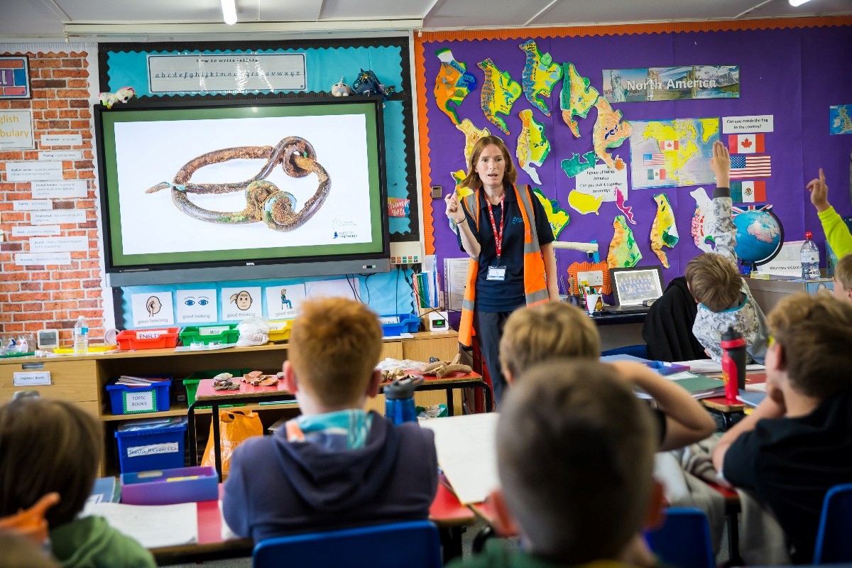
Andrew Milner, Executive Head Teacher from Birdlip Primary School, said: “This was a wonderful opportunity to study the A417 Missing Link in depth. The children engaged with the archaeology to find out exactly what came before the road and then where the new road will go and how it will look. The team took the time to answer all the questions fully, in a way that was relevant to the children and the staff who turned up.”
-
29 June 2021
Development Consent Order application accepted for examination
We are pleased to confirm that our proposals for the A417 Missing Link have been accepted by the Planning Inspectorate for formal examination.
This signifies a huge step towards delivering a landscape-led highways scheme that will provide a safe and resilient free-flowing road while conserving and enhancing where possible the special character of the Cotswolds Area of Outstanding Natural Beauty.
Thank you to everyone who has supported us getting to this point, providing your feedback to help us shape the scheme.
Next steps
The Planning Inspectorate will now examine the Development Consent Order (DCO) application through written representation and public hearings. They will then review all the evidence and make a recommendation to the Secretary of State for Transport, who has the final decision on whether the scheme should go ahead.
The examination and decision-making process will take over a year. You can find our more information about this process and how to get involved on the Planning Inspectorate’s website.
Our application
You can now view our full application on the Planning Inspectorate’s website and you’ll also find a few bits of useful information below.
- Scheme map – this gives an overview of the scheme design
- Our response to consultation 2020 and next steps
- A guide to our DCO application - links to the different sections of the application to help you find what you need
- Our Environmental Statement
Project information
Project profile
Visit our A417 Missing Link project profile pages.
Find out how we're making sure our scheme matches the character of its surroundings.
Progress in 2025
Manage your cookie preferences to view the content on this page
Visit our Customer Hub
Our project Customer Hub is now open every Tuesday and Wednesday between 10am and 2pm.
You can speak to members of our team, who can tell you about our work and answer your questions.
Location
Kier Crusher Plant, GL4 8JX (past Acorn House)
Directions
Northbound access via the new B4070
Travelling on the A417 from Cirencester:
- continue until you reach Shab Hill Junction
- take the slip road off the new A417 and turn right at the roundabout onto the new B4070
- follow the signs for the Crusher Compound
- continue on the B4070 and then turn right at the crossroads
- continue for approximately 100 metres, then turn right and follow the road past Acorn House (formally, McCarthy-Taylor Systems), which will be on your right
- please do not stop at Acorn House
- go through the traffic lights and take an immediate left to our site compound (Crusher)
Southbound access via the new B4070
From Air Balloon and Ullenwood roundabout:
- join the new A436 slip road
- continue (for approx 750 metres) up to the new Shab junction and turn right to continue through the underpass
- follow the signs for the Crusher Compound
- continue on the B4070 and then turn right at the crossroads
- follow the road past Acorn House (formally, McCarthy-Taylor Systems), which will be on your right
- please do not stop at Acorn House
- go through the traffic lights and take an immediate left to our site compound (Crusher)
A gates person will be at the entrance to help you if needed.
You must stick to the site speed restriction of 10mph. Please reverse park.
Manage your cookie preferences to view the content on this page
Overview
The A417/A419 provides an important route between Gloucester and Swindon that helps connect the Midlands/North to the South of England. It's an alternative to the M5/M4 route via Bristol. The Missing Link itself is a three-mile stretch of single-lane carriageway on the A417 between the Brockworth bypass and Cowley Roundabout in Gloucestershire.
The Missing Link causes many problems for road users and those who live or work in the area. Congestion can be frequent and unpredictable, so some motorists divert onto local roads to avoid tailbacks. This causes difficulties for neighbouring communities and local roads that were not built to accommodate so much traffic. Poor visibility and other factors also mean that accidents, many of which are serious, occur frequently along this section of road.
We’re improving the A417 with a scheme that includes:
- 4 miles of new dual carriageway connecting the existing A417 Brockworth bypass with the existing A417 dual carriageway south of Cowley
- a section to the west of the existing Air Balloon roundabout that will follow the existing A417 corridor. However, the section to the south and east of the Air Balloon roundabout will be offline, away from the existing road corridor
- a new junction at Shab Hill, providing a link from the A417 to the A436 towards Oxford and into Birdlip
- a new junction near Cowley, to replace the existing Cowley Roundabout
- the existing A417 between the Air Balloon roundabout and the Cowley Roundabout is being repurposed. We are converting some lengths of this existing road into a route for walkers, cyclists and horse riders, while retaining other sections to maintain local access for residents.
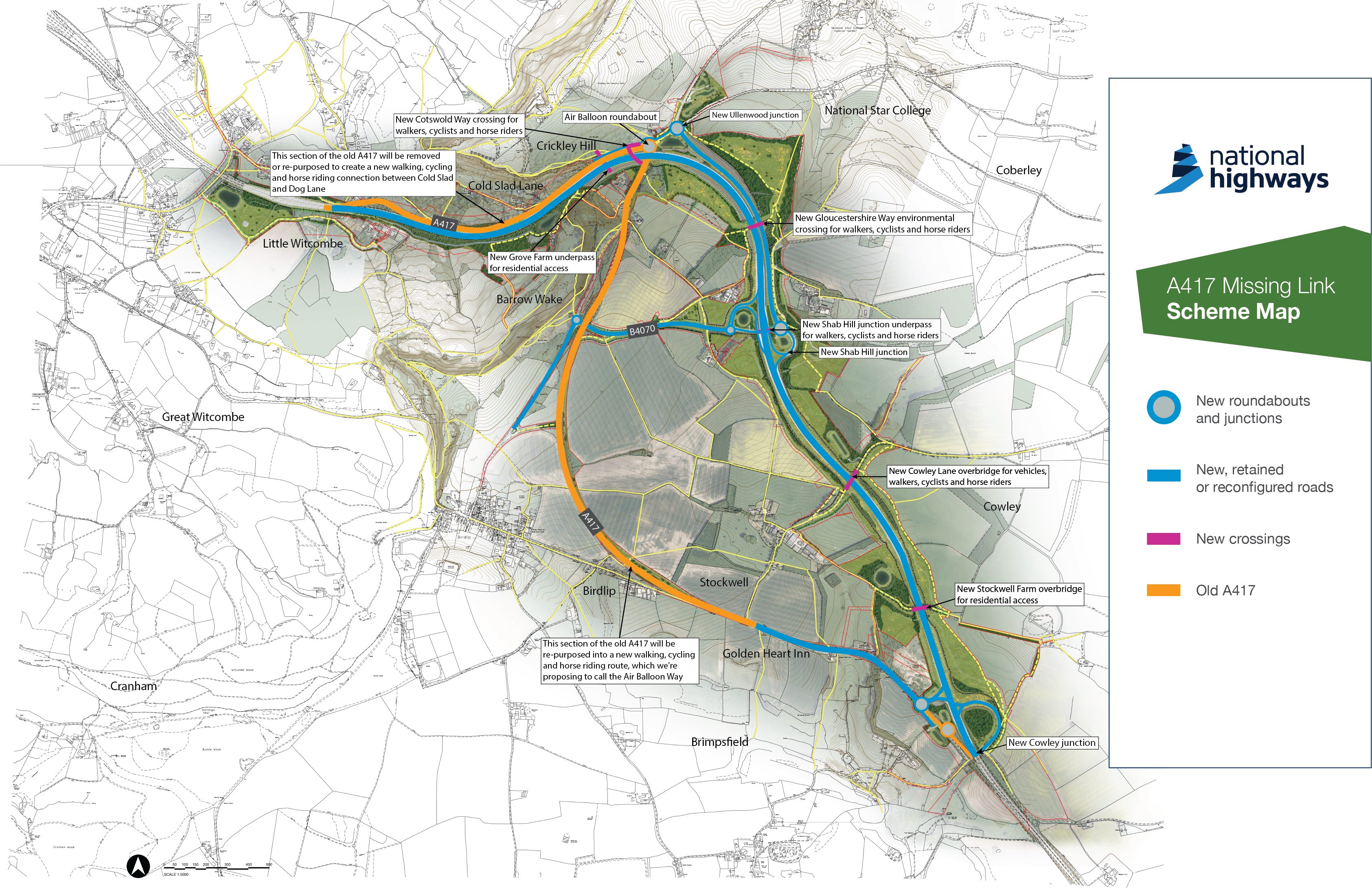
Click on image to enlarge
Benefits
Our scheme to improve the A417 Missing Link will bring significant benefits to the local area.
Our scheme has four key objectives:
Transport and safety
Reducing delays, creating a free-flowing road network and improving safety along this stretch of the A417
Environment and heritage
Reducing the impact on the landscape, natural and historic environment of the Cotswolds. Where possible, enhancing the surrounding environment
Community and access
Reducing queuing traffic and pollution. Improving access for local people to the strategic road network. Supporting residents and visitors’ enjoyment to the countryside
Economic growth
Helping boost growth and prosperity by making journeys more reliable and improving connectivity.
Our work in the local community
We want to make a positive difference for communities living near our roads, especially where we’re carrying out works.
Find out more about our work in the local community.
Documents
Development Consent Order documents
The Development Consent Order (DCO) process was established by the Planning Act 2008 and is used for certain large and complex schemes (including highway improvements) that have been designated as a Nationally Significant Infrastructure Project (NSIP) by the Government.
The Secretary of State for Transport granted development consent for the A417 Missing Link Development Consent Order (DCO) on 16 November 2022. Links to key DCO documentation can be found below:
- Examining Authority’s report and recommendations to the Secretary of State for Transport
- Secretary of State for Transport’s decision letter and statement of reasons
- DCO as made by the Secretary of State for Transport
The made DCO is Statutory Instrument 2022 No. 1248 and is available to view at legislation.gov.uk.
Development Consent Order – Requirements Register
Requirements are conditions that have been included in the DCO, these control how the project must be implemented (constructed and maintained). Implementing the DCO in accordance with these conditions involves completing approval processes that have been defined in the DCO. These processes are referred to here and in the DCO as “discharging” the requirements.
This Requirements Register is a live document and will be updated as the process to discharge the requirements progresses.
The latest version will always be published below:
View the Requirements Register
This register will be maintained for three years following completion of the project. The register sets out:
- each requirement
- whether the requirement needs approval by the Secretary of State (or other duty holder)
- whether any approval has been applied for or given
Traffic information
Information about scheduled roadworks and events on our motorways and major roads.Sign up for updates!
Keep up to date with what's happening on this scheme by signing up to our updates.
