A46 Coventry junctions upgrade
The A46 is a strategic road link between the East and West Midlands, connecting Coventry and Warwickshire to the motorway network. Traffic congestion has led to slower speeds, longer trip times and more queueing for drivers. By upgrading the A46 we’ll unlock this congestion, improve journey reliability and support economic growth across the West Midlands.
Latest updates
-
29 June 2026
A46 Coventry junctions (Walsgrave) – early works starting 13 July 2026
To prepare for the main construction works, we'll be closing the A46 overnight on several occasions and making some changes to the road.
We need to close the road overnight to safely install signage and to build temporary site accesses.
We'll also be reducing the speed limit on this section of the A46 to 50mph while we're working.
We know this will affect your journey, and we appreciate your patience while we do this important work.
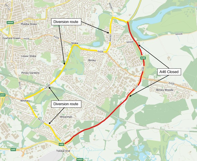
From 13 July to 31 July 2026, we'll be closing the A46 northbound overnight.
A46 northbound closure diversion route
From 3 August to 4 August 2026, we'll be closing the A46 southbound overnight.
A46 southbound closure diversion route
All closures run from 8pm to 6am, Monday to Friday.
The existing laybys on the A46 northbound and southbound, between Walsgrave junction and M6 junction 2, will be used for site access during the scheme.
We'll close them from 13 July, and later remove them to make way for the new junction.
-
26 June 2026
Thank you for coming to our public information events
Last week, we held two public information events for the A46 Walsgrave scheme - at Tesco, Walsgrave and Warwickshire Shopping Park.
We were delighted to welcome over 300 visitors across both days.
It was great to speak with so many of you about the scheme and hear your questions and views.
Your feedback helps shape how we plan and deliver our work, and we're grateful to everyone who took the time to come and find out more.
If you couldn't make it to our events and have questions about our work, please contact our project team at A46CoventryJcns@nationalhighways.co.uk
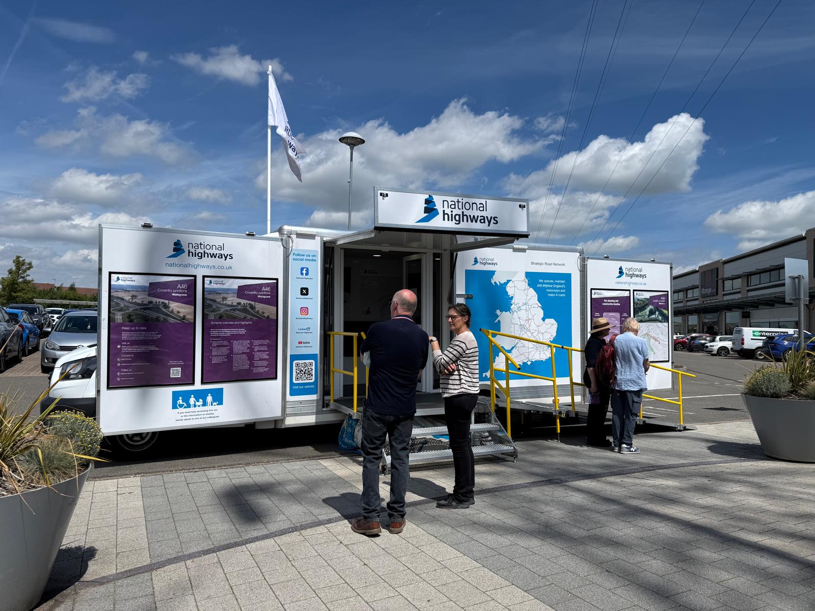
Our mobile exhibition at one of our recent information events -
18 May 2026
Public Information Events in June – Come and Meet the Team
We’re holding a series of drop in public information events in June 2026.
Come along to view our plans, learn more about our work, and speak directly with our team. We’d be happy to answer your questions.
Dates and locations:
- Monday 15 June – Tesco Superstore, Clifford Bridge Road, Coventry, 10am–4pm
- Tuesday 16 June – Warwickshire Shopping Park, 10am–4pm
-
11 March 2026
A46 Coventry Junctions (Binley) - road closure
We're installing new street lights, resurfacing, and undertaking drainage maintenance on the A46 Binley Junction near Coventry.
This work will ensure the junction continues to operate safely and efficiently.
The A46 will be closed from Monday 24 March until Thursday 2 April 2026.
We'll work between 8pm and 6am on weeknights only, weather permitting.
A46 Binley junction diversion route map
A clearly signed diversion route will be in place.
-
04 February 2026
A46 Walsgrave Development Consent Order approved
On 4 February 2026, Lord Hendy, on behalf of the Secretary of State for Transport approved the Development Consent Order (DCO) for the A46 Walsgrave scheme, part of the wider A46 Coventry junctions upgrade.
This approval gives us the planning permission needed to start work on improving one of the UK’s major trade routes. The A46 supports millions of people, connects inland manufacturing and distribution hubs with major ports, and keeps jobs and businesses moving.
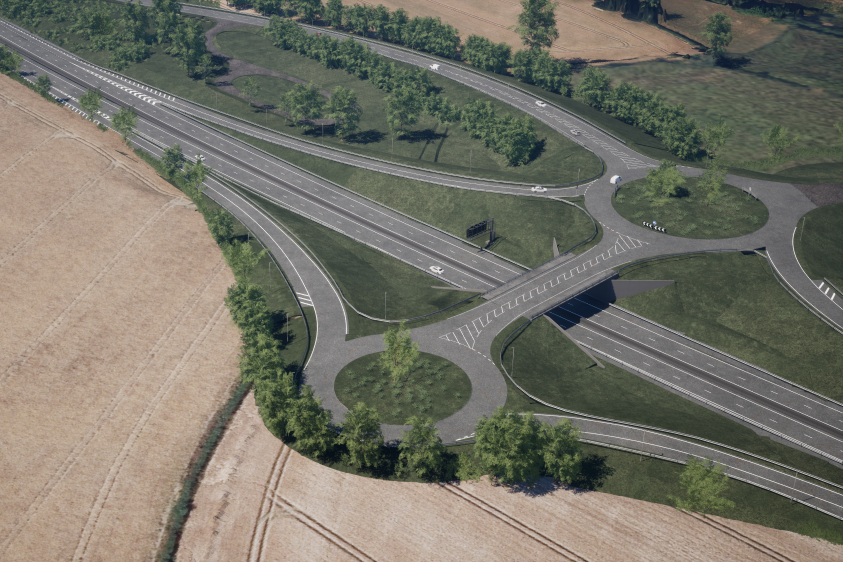
How the new junction will look when completed Emma Winter, Project Manager at National Highways, said:
“Motorways and major A roads carry a third of all traffic and two-thirds of freight in the UK. The A46 is a vital trade route between the south west, the midlands, and the north. We need to remove this bottleneck on the outskirts of Coventry.
“The upgraded Walsgrave junction will reduce delays, provide extra capacity, improve connectivity, and make journeys safer for the 57,000 drivers who use this road every day.”
The new junction will allow for a free-flowing A46 Construction on the Walsgrave junction is expected to start in autumn 2026, with the £112 million scheme opening to traffic in 2028.
For more information, you can view the documents on the Planning Inspectorate’s website under ‘Documents.’
-
10 September 2025
A46 Walsgrave
The examination phase of the Development Consent Order (DCO) ended on Friday 12 September 2025.
The Examining Authority (ExA) will now begin preparing their report and recommendations, which will be submitted to the Secretary of State (SoS) for Transport. A final decision on our DCO is expected to be announced in March 2026.
Over the next three months, the ExA may continue to engage with Interested Parties if they have any questions as they prepare their report.
If you are interested in reading any of the documentation submitted as part of the examination, please visit the Planning Inspectorate Website.
-
16 December 2024
Our Development Consent Order (DCO) application has been accepted
On 12 December 2024, the Planning Inspectorate confirmed they have accepted our application for a Development Consent Order (DCO) for detailed examination.
A notice under Section 56 of the Planning Act 2008 informs the public of this.
Read the A46 Walsgrave Section 56 Notice.
After finalising our plans for the improvements to the A46 Coventry Junction, we submitted our DCO to the Planning Inspectorate on 14 November 2024. Our DCO is a collection of assessments, data, plans and proposals, which outline how we plan to deliver the scheme. The application also includes our consultation report, which outlines the comments and questions we received during our statutory and targeted consultations, along with our responses.
Our application documents are available on the Planning Inspectorate Website.
The planning process takes around 12 months including six months of examination, some taking place at public hearings. Watch this short video from the Planning Inspectorate, explaining the six stages of the development consent process.
What happens next - the pre-examination stage
Anyone, including businesses, or individuals, can register as an 'Interested Party'. By doing this, you’ll be able to submit a written representation or attend a public hearing to present your views on the project. We’ll publish details of how to do this on our scheme webpage. During this stage, the Planning Inspectorate will also:
- appoint a panel of inspectors to serve as the Examining Authority
- hold a first meeting, called the 'Preliminary Hearing' to discuss procedural issues and the timetable for examination
Please note: The Transport Secretary has commissioned a review of the Department for Transport's spending portfolio, including current and future road schemes. While the review is ongoing, we’re continuing with our work on the scheme.
Read the Secretary of State’s written statement to Parliament of 30 July 2024.
Keep in touch
You can sign up to receive email alerts when we update information on the A46 Coventry Junctions (Walsgrave) scheme. You can also register to receive email alerts from the Planning Inspectorate.
You can contact our team directly by email if you have any questions about the process: a46coventryjcns@nationalhighways.co.uk -
22 August 2024
Supplementary consultation with stakeholders begins
As mentioned in our previous update, we’ve been analysing your responses from the statutory consultation which closed in December 2023. Since then, we’ve used feedback and ongoing engagement to update our Scheme design.
Due to recent developments to the scheme design and updates that have been made, we’re now undertaking a supplementary consultation with people who have an interest in the land impacted by the changes. This consultation activity will take place over the next four weeks so we can gather feedback on our latest scheme proposals. Those impacted will be receiving a letter from us.
Most of our updates have been made to the scheme boundary, also referred to as ‘draft order limits’ or the ‘red line boundary’. This is the land we would seek to acquire either temporarily or permanently if our application for a Development Consent Order (DCO) is approved.
To support this consultation, we have produced a schedule of proposed changes, updated design drawings and land use plans.
If you have any queries regarding our latest updates, please email: a46coventryjcns@nationalhighways.co.uk
-
23 July 2024
Overnight closures for routine landscaping maintenance & barrier inspections
Our teams will be carrying out work on both lanes and slip roads of the A46 between Toll Bar and Walsgrave Junctions from Monday 29 July to Friday 2 August.
To ensure the safety of our workforce and to protect motorists, we will be closing this section of the A46 north and southbound.
The closure will be in place between 8pm and 6am between Monday 29 July to Tuesday 30 July and then between Wednesday 31 July to Friday 2 August. There is no overnight closure on Tuesday 30 July.
In advance of the closures, we’ll put in place a clearly signed diversion route which has been agreed with Coventry City Council. This is the most suitable route for both the amount and type of traffic being diverted.
We apologise in advance for any inconvenience you may experience, and our team will make every effort to manage noise levels and minimise disruption to the local community.
-
14 May 2024
We've published our Consultation Summary Report
We’ve been reviewing your responses to our statutory consultation in December 2023,
We’ve produced a report that summarises the common themes and comments we received. The summary report is to give you an early look at the results.
A45 Coventry junctions (Walsgrave) Public consultation summary
We're still working on our full consultation report. We'll submit this with our Development Consent Order (DCO) application to the Planning Inspectorate
If you have any questions, please email: a46coventryjcns@nationalhighways.co.uk.
-
07 December 2023
Consultation now closed
Our public consultation has now closed. We'd like to thank everybody who took the time to provide us with feedback on our proposed design.
We’ll now review all the suggestions and comments received and we’ll take time to consider your feedback when making further refinements to the proposed design and to develop our planned mitigation measures.
We’ll set out a summary of the responses received and the themes raised and aim to publish this in March 2024. The full consultation report, summarising all the responses, and describing how our proposals have been informed and influenced by them, will form part of our Development Consent Order (DCO) application. This will be available to the public if our application is accepted by the Planning Inspectorate. We expect to submit our application by autumn 2024 and, if consent is granted, work will start in autumn/winter 2026.
In addition to this consultation process, we’ll continue to engage with anyone interested in or impacted by the scheme.
If you have any queries about this scheme please contact the project team directly by calling 0300 123 5000 or emailing A46CoventryJcns@nationalhighways.co.uk
This short video gives more information about how we develop major road projects and the process we expect to follow to obtain planning permission to build the scheme.
-
13 November 2023
Statutory consultation launched
We’re consulting on our proposals for the A46 Coventry junctions (Walsgrave) scheme and want to hear your views on our latest design.
A46 Coventry junctions (Walsgrave): Preferred route fly through video - visual description.
The consultation will run from 25 October until 11.59pm on 6 December 2023.
If you’ve received a letter from us informing you that we have identified you as a Section 42 category 3 landowner or occupier, the consultation period will remain open until 11:59pm on 22 December 2023.
Your feedback is important and will continue to help shape the design of the scheme before we submit an application for a Development Consent Order (DCO).
What you need to know:
- To find out more about our proposals and the consultation, please see our consultation brochure
- You can also view our mapbook, which contains a range of technical drawings including General Arrangement plans
- Our environmental information can be seen in our Preliminary Environmental Information Report (PEIR) or a summarised version in our Non-Technical Summary
- Share your views and complete our online response form on Citizen Space
Public consultation events
One of the best ways to find out more about our proposals is to come to one of our public consultation events.
We’ll be holding three large in-person events where we’ll be sharing lots of information, including a detailed breakdown of our proposals and large scale maps. You’ll also have the chance to speak to our technical experts, who’ll be available to answer your questions at the locations listed below:
Venue address Date and time of event Wyken Community Centre, Ennerdale Lane, Coventry, CV2 5PY Saturday 4 November 2023, 10am to 2pm Warwickshire Shopping Park Community Centre, 1c Kynner Way, Binley, Coventry, CV3 2SB Friday 17 November 2023, 2pm to 8pm Brinklow Community Hall, 43 Broad Street, Brinklow, Rugby, CV23 0LS Thursday 30 November 2023, 2pm to 8pm Alternatively, we’ll also be holding three smaller pop-up events around Coventry. Although there’ll be less information on display due to the size constraints of the venues, you’ll still be able to pick up a scheme brochure and response form, and speak to some members of our project team:
Venue address Date and time of event Broadgate, Coventry City Centre (National Highways engagement van) Thursday 9 November 2023, 10am to 4pm Tesco (Walsgrave Superstore), Clifford Bridge Road, Coventry, CV2 2TS Thursday 16 November 2023, 10am to 2pm Coombe Country Park visitor centre, Brinklow Road, Coventry CV3 2AB Saturday 25 November 2023, 10am to 2pm Online event
Our online event took place at 6pm on Tuesday 7 November. Click below to:
Consultation materials
All of our consultation materials can be viewed online in the 'Consultation 2023' section below.
Printed copies of our consultation brochure and response form are available free of charge at deposit locations and in-person consultation events throughout the consultation period. The deposit locations are:
Location Opening hours Day Time Caludon Castle School and Community Library, Axholme Road, Wyken, Coventry, CV2 5BD Monday
Tuesday
Wednesday
Thursday
Friday
Saturday
Sunday
2pm – 6pm
2pm – 6pm
Closed
2pm – 6pm
2pm – 6pm
10am – 4pm
Closed
Coventry Council House, Earl Street, Coventry, CV1 5RR Monday to Friday
Saturday
Sunday
9am – 5pm
Closed
Closed
Rugby Borough Council, Town Hall, Evreux Way, Rugby, CV21 2RR Monday to Friday
Saturday
Sunday
9am – 5pm
Closed
Closed
Warwickshire County Council, Shire Hall, Warwick, CV34 4RL Monday to Friday
Saturday
Sunday
8am – 6.30pm
9am – 1pm
Closed
Willenhall Library, Hagard Community Space, Remembrance Road, Coventry, CV3 3DG Monday
Tuesday
Wednesday
Thursday
Friday
Saturday
Sunday
10am – 7pm
10am – 7pm
Closed
10am – 7pm
10am – 7pm
9am – 4pm
Closed
Wolston Library and Information Centre, Warwick Road, Wolston, Coventry, CV8 3GX Monday
Tuesday
Wednesday
Thursday
Friday
Saturday
Sunday
2.30pm to 5pm
2.30pm to 5pm
2.30pm to 5pm
10.30am to 1pm
10.30am to 1pm
10.30am to 1pm
Closed
The opening times of these deposit locations may be subject to change due to circumstances out of our control. If in doubt, please contact a location before visiting.
How to respond to our consultation
- Complete our response form online via Citizen Space
- Email your response to: A46CoventryJcns@nationalhighways.co.uk
- Send a completed response form or letter to: Freepost A46 WALSGRAVE SCHEME
For further information about the scheme or the consultation, please contact us using the scheme email address A46CoventryJcns@nationalhighways.co.uk or call our Customer Contact Centre on 0300 123 5000.
-
03 February 2023
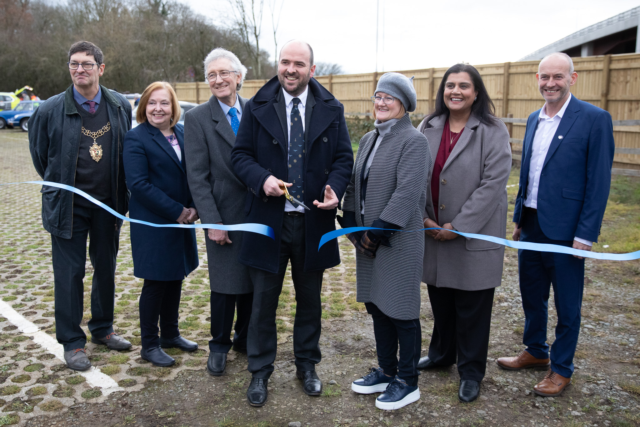
Binley junction upgrade now complete
Our upgrade to Binley Junction, part of our work on the vital A46 route near Coventry is now complete. It means that drivers travelling along the length of the A46 will no longer need to slow down to use the roundabout, reducing congestion and making journeys safer and more reliable.
The improvements have included:
- the construction of a new dual carriageway flyover above the existing roundabout
- the construction of new northbound and southbound on and off slip roads
- upgraded access for pedestrians and cyclists, providing safer and improved access underneath the new flyover
- installing a toucan crossing along the A428, underneath the new flyover

(A46 Binley junction at night)
Work started in 2020 with utility services diverted around the area, ensuring essential supplies to nearby residents and businesses were maintained. In early 2021 we moved traffic in to narrow lanes, creating space and allowing us to safely modify the existing carriageway and start building four new slip roads. Over two weekends in December 2021, specialist engineers carried out work to lift 32 steel beams – with a combined weight of 720 tonnes - into place to form the new flyover – a huge milestone for the project!
In July 2022 we were able to open complete the flyover, ensuring it opened in time for the 2022 Commonwealth Games, with all slip roads fully open to motorists and road closures around the flyover lifted in November 2022.
Chair of Binley Woods Parish Council, Paul Salisbury said: “The completion of the new flyover is a real game-changer for local people. The movement of vehicles around the old junction was chaotic so it’s great to see the new layout open to traffic and it means through traffic can now stay on the A46.
We’re keen to see work progress at Walsgrave junction as this will make journeys even smoother for drivers using the A46.”
Roads Minister Richard Holden, who attended the ceremony, said:
“National Highways’ upgrade of this vital section on the A46 will help families, businesses and commuters across Coventry, Rugby and Warwickshire have safe and reliable journeys.
“This was an enormous piece of work and I extend my thanks to everyone who worked on it and to the local community for their ongoing patience."
(Richard Holden MP officially opening the flyover)
Throughout the duration of the project, we were committed to investing locally. Our compound offices, constructed by local company Innovare Systems, were an industry first. Made from a timber panel system, the building provided high thermal performance and airtightness. This highly insulated and cost effective building was extremely energy efficient and provided a low carbon footprint.
Beechwood Trees and Landscapes Ltd, located less than a mile from the site, were also one of the first contractors on site.
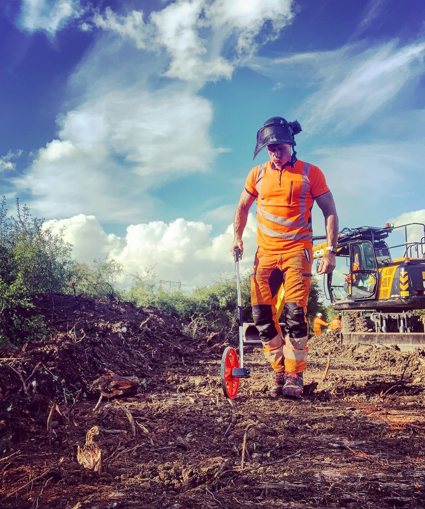
(Arborist measuring on site)
We’ve worked closely with local residents and businesses to ensure disruption has been kept to a minimum. We also wanted to ensure we made a difference to the local community. The scheme has helped parish councils and community groups in a variety of ways:
- We’ve supported Coventry Foodbank, part of the @Trussell Trust. Throughout the duration of the project we made regular contributions including a massive 165kg donation in October 2022.
- Through a £35,000 cash injection from our designated funds programme, we’ve helped protect and improve access to Piles Coppice, an ancient woodland close to the project, by replacing damaged fencing and installing new bollards
- We worked alongside volunteers at Warwickshire Wildlife and took part in a litter pick at Brandon Marsh Nature Reserve, near to the scheme. We were also supported on the day by volunteers at Midland Langar Seva Society (MLSS) who provided the team with food and drinks. Since 2014 MLSS have been supporting communities in Coventry, serving over 3,000 meals per week. Find out more information about them here: https://midlandlangarseva.org/
One of our objectives for our upgrade scheme at Binley junction was to ensure there was minimal impact on the natural and built environment. The scheme was planned and managed to reduce or eliminate any adverse impacts on species of interest and their habitats, particularly within the local nature reserves that bordered the scheme.
We built two new ponds to provide natural pollution control and act as sustainable urban drainage for water run-off. These ponds have been carefully landscaped and planted up to provide a habitat for wildlife including amphibians and reptiles.
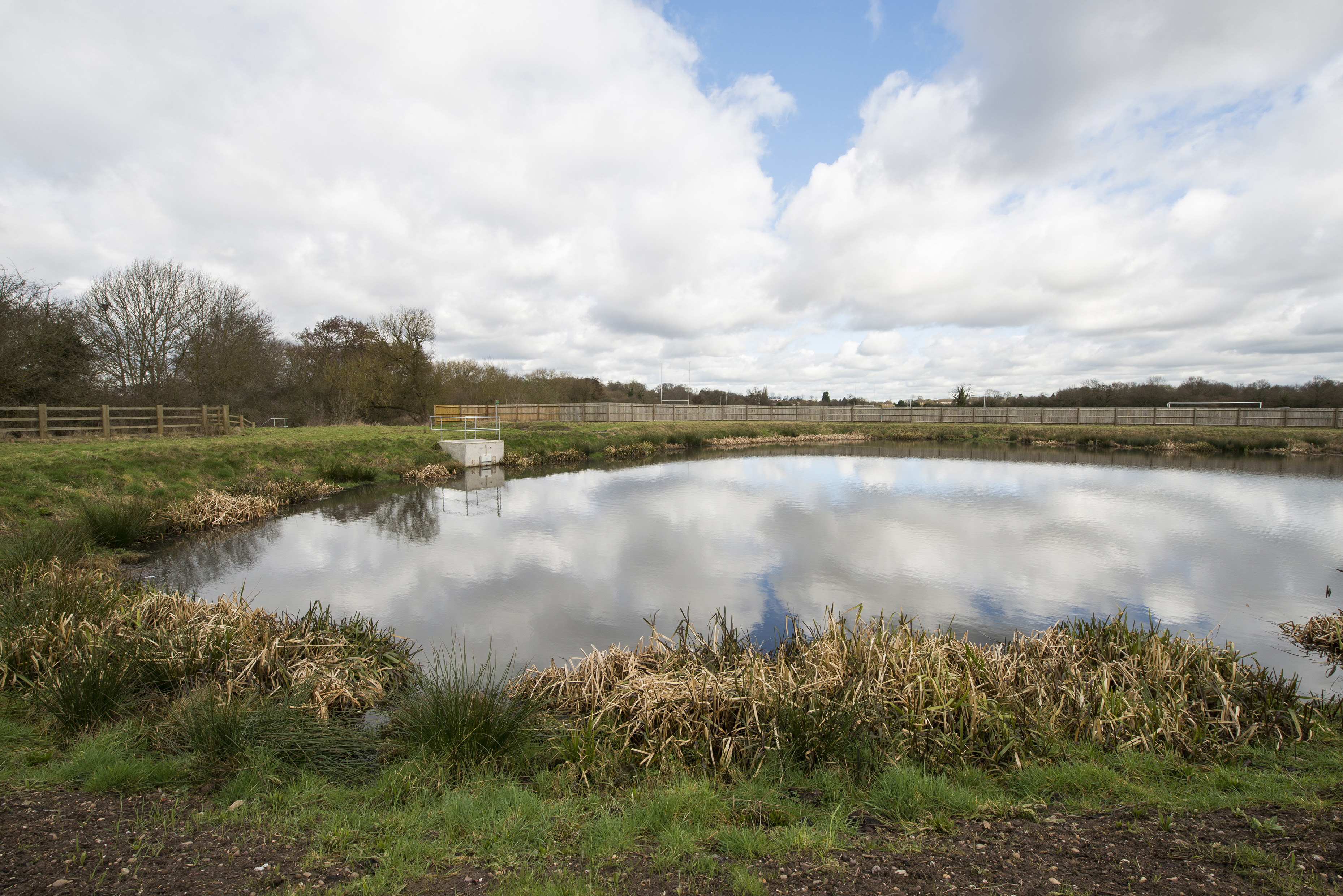
(Pollution control ponds)
Barriers alongside the new northbound entry slip road aid in protecting local housing from the impacts of the road and close board fencing on the southbound entry slip road provides screening to nearby Piles Coppice.
All landscaping uses native vegetation found in the local area to encourage wildlife and provide a green corridor linking the scheme to adjacent protected habitats.
We’ve also helped deliver a sustainable project by:
- using hydrotreated vegetable oil (HVO) fuel in battery generators on site, reducing carbon emissions by 97%
- using hydrogen and battery tower lights to reduce noise and air pollution
- landscaping using native vegetation found in the local area to encourage wildlife
- installing new low-energy LED lighting across the scheme
We were delighted to welcome all of our guests, including Transport Minister Richard Holden, to our opening ceremony on Friday 3 February.
We celebrated the achievements of the project and those who have worked on it along with highlighting the work we’ve done in our local community over the last three years. Guests were able to learn how the flyover was built with presentations by staff from National Highways and our delivery integration partners at Octavius.
Click here to view a copy of our opening ceremony celebration brochure.
-
27 July 2022
A46 Binley Flyover opens
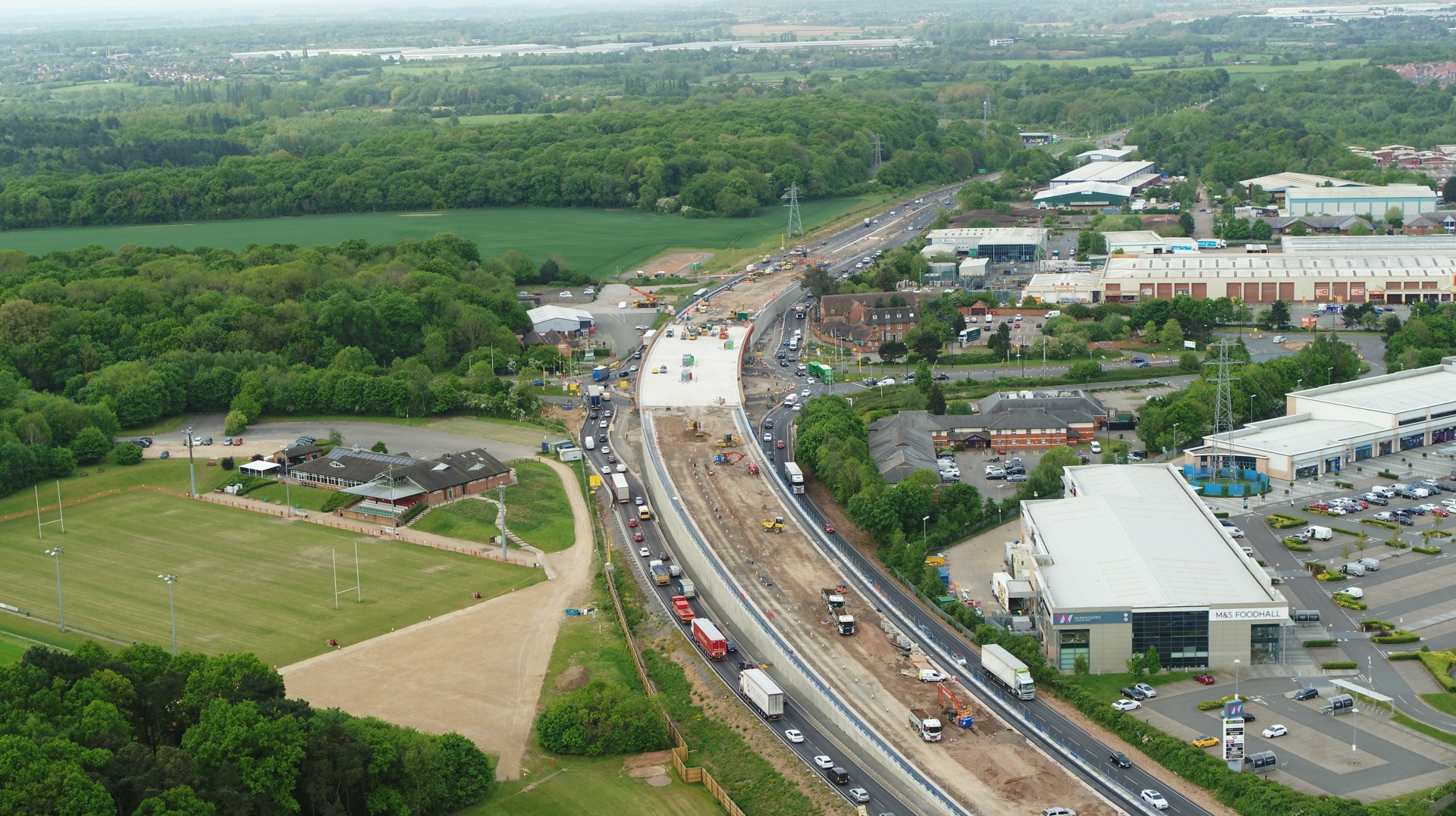
(Aerial view of Binley Flyover)
The new 14,000-tonne flyover that separates long distance and local traffic on the A46 at Binley will open on Friday 29 July. It means that drivers travelling along the length of the A46 will no longer need to slow down to use the roundabout, reducing congestion and making journeys safer.
Drivers using the new road for the first time are being advised that there is a temporary 40 mph speed limit in place with two lanes running in each direction while some remaining work takes place elsewhere on the structure.
Work will still be taking place at Binley in two phases until Autumn 2022 with slip road closures required while teams complete the final stages of the project. Clearly signed diversion routes for affected traffic will be in place.
-
14 June 2022
Preferred route announcement
Alongside our ongoing work to upgrade Binley junction, we’ve been assessing various options to upgrade the junction at Walsgrave. Our work showed that only one option was viable and could deliver the required improvements at the junction.
Between January 2022 and February 2022, we held a public consultation on this viable option, known as Option 11. We also shared detail on the discounted options and explained why these were not viable.
The feedback received during the consultation showed support for improvements at Walsgrave junction and support for Option 11 and we are therefore taking this scheme to the next stage of design development.
You can find out more about the preferred route in our brochure
What option 11 looks like
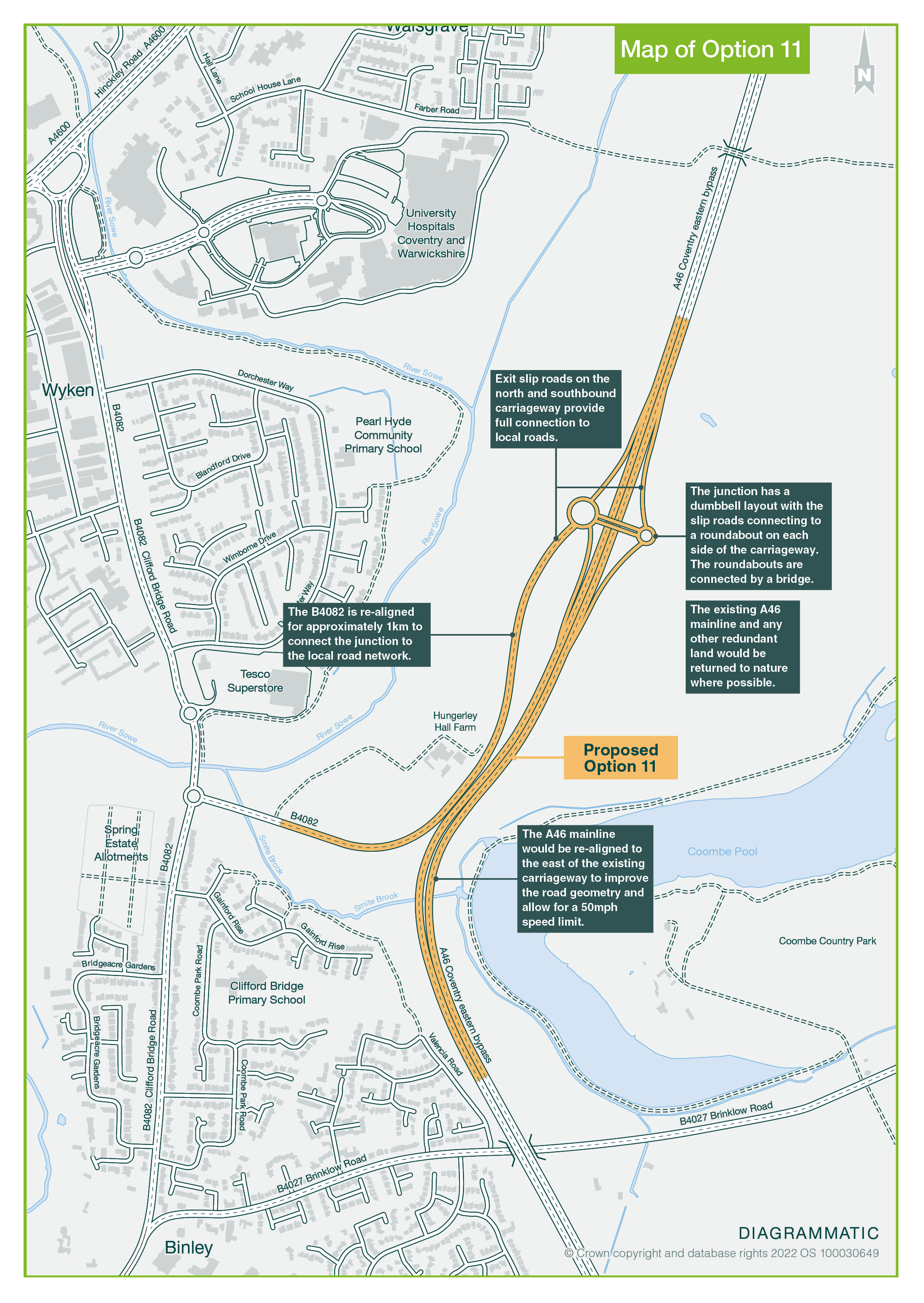
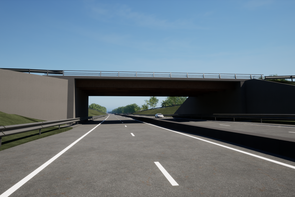
Option 11 would provide a fully grade separated junction approximately 800m north of the existing A46 Walsgrave junction. Exit and entry slip roads would be provided on both the north and southbound carriageway allowing full connection to the local road network.
The junction would be in a dumbbell layout with the slip roads connecting to a roundabout on each side of the carriageway with the roundabouts connected via an overbridge.
A number of comments were raised in response to the consultation, which we’ll investigate further at the next stage of design. These include:
- access to University Hospital Coventry & Warwickshire
- walking and cycling provision
- a proposed 50mph speed limit
- the impact on local road network
What happens next
Now we have announced our preferred route, we’ll undertake the next stage of design development. This is when we’ll develop more detail on the highway structures and overall design. It’s also when the next stages of environmental assessments are completed and we’ll look at the steps we can take to reduce any environmental impacts. During this stage of the scheme, we’ll hold another public consultation, giving you the opportunity to comment on a more developed proposal.
-
19 January 2022
Watch how 32 giant steel beams were lifted into place to form a flyover at Binley junction
This new time-lapse footage shows the moment huge steel beams were lifted into place to form a flyover at Binley junction.
Specialist teams carried out the work over two weekends in December, using a 750-tonne crane to lift 32 beams - with a combined weight of 720 tonnes - into place.
This work is part of our £61 million investment to transform Binley junction by building a flyover to separate long distance and local traffic. This means drivers staying on the A46 will no longer need to slow down to use the roundabout, reducing congestion and making journeys safer.
If you’d like more information about the A46 Coventry junctions upgrade scheme you can contact us by:
- emailing A46CoventryJcns@nationalhighways.co.uk
- calling 0300 123 5000 (this line is available 24 hours a day)
Project information
Overview
We’re investing in the A46 at Coventry by upgrading two junctions to:
- improve safety
- increase road capacity
- relieve traffic congestion
- smooth the flow of traffic
- support the growing economy
The upgrade is being delivered in two phases.
Binley junction
The A46 Binley junction improvement scheme was opened to traffic in November 2022, converting the junction from an at-grade signalised roundabout to a grade separated junction. There are concerns that without further investment to reduce congestion on the A46, the benefits of the improvement works at Tollbar End junction would be limited. In particular, the current delays at the Walsgrave junction could undermine the existing investment which has been made on the A46 improvements.
Walsgrave junction
The Coventry junctions (Walsgrave) scheme is part of our commitment to improve the A46 ‘Trans-Midlands Trade Corridor’ between the M5 and the Humber Ports.
The Coventry junctions scheme involves the upgrade of two at-grade junctions (Binley and Walsgrave) to provide relief from traffic congestion and to improve journey times by increasing the capacity on the A46 between the M6 and the M40. This will benefit both the strategic and local traffic needs and support future growth forecasts from Coventry City Council.
Walsgrave junction is the last remaining roundabout east of Coventry and north of Tollbar End junction that is at-grade, and as such it is a pinch point for traffic. The Tollbar End junction and M6 Smart Motorway improvements have increased the pressure on Binley and Walsgrave junctions.
We held our statutory consultation from 25 October to 6 December 2023.
Project timeline
2016
Project begins
2018
Option assessment
January-February 2022
Consultation on route option
June 2022
Preferred route announcement
2023
Public consultation
2024
DCO application submission
Early 2026
DCO decision
2026
Construction start
2028
Road open to the public
Benefits
The aims of the scheme are to:
- improve safety
- support the growing economy
- support the smooth flow of traffic
- increase capacity
- relieve congestion
Consultations
2023
A46 Coventry Junctions - Walsgrave Statutory Consultation - 25 October - 22 December 2023
A45 Coventry junctions (Walsgrave) Public consultation summary
2022
A45 Coventry junctions (Walsgrave) Public consultation summary
A46 Coventry Junctions Upgrade - Walsgrave Junction - Public Consultation - 11 January - 14 February 2022
Documents
Public Inquiry 2020
Statement of Case (Binley) (revised)
Appendix 1.A - Draft and Made Orders
Appendix 1.B - Environmental Assessment (revised)
Appendix 1.C - Consultation documents and documents previously on deposit
Appendix 1.D - Core legislation (Acts)
Appendix 1.G - National Planning Policy Guidance
Appendix 1.H - Local and regional planning and policy documents
Appendix 1.I - Transport and Traffic
Proofs of Evidence and Appendices
Notice of Public Inquiry - Highways Act 1980 and Acquisition of Land Act 1981
Traffic information
Information about scheduled roadworks and events on our motorways and major roads.Sign up for updates!
Keep up to date with what's happening on this scheme by signing up to our updates.
