Your questions about the Winterbourne Stoke bypass

The proposed A303 will pass about 400 metres north of the current road in Winterbourne Stoke. This route was preferred by a majority of people responding to our statutory consultation in 2018.
Will the bypass be visible?
Most of the bypass will be landscaped with the road largely hidden from view. On some sections, the road will be screened by environmental “bunds” (or false cuttings) between 1 to 3 metres high. These engineered embankments will be graded and softened to blend into the rolling chalk downland.

Approx 1 kilometre east of Yarnbury Castle

Approx 300 metres east of the River Till valley
We will plant native woodland and trees in some locations along the bypass which will help to provide a visual screen for the road. The majority will be planted as saplings up to 900 millimetres in height as this is usually the best way to establish woodland in the long term rather than larger tree stock.
How will the road cross the River Till?
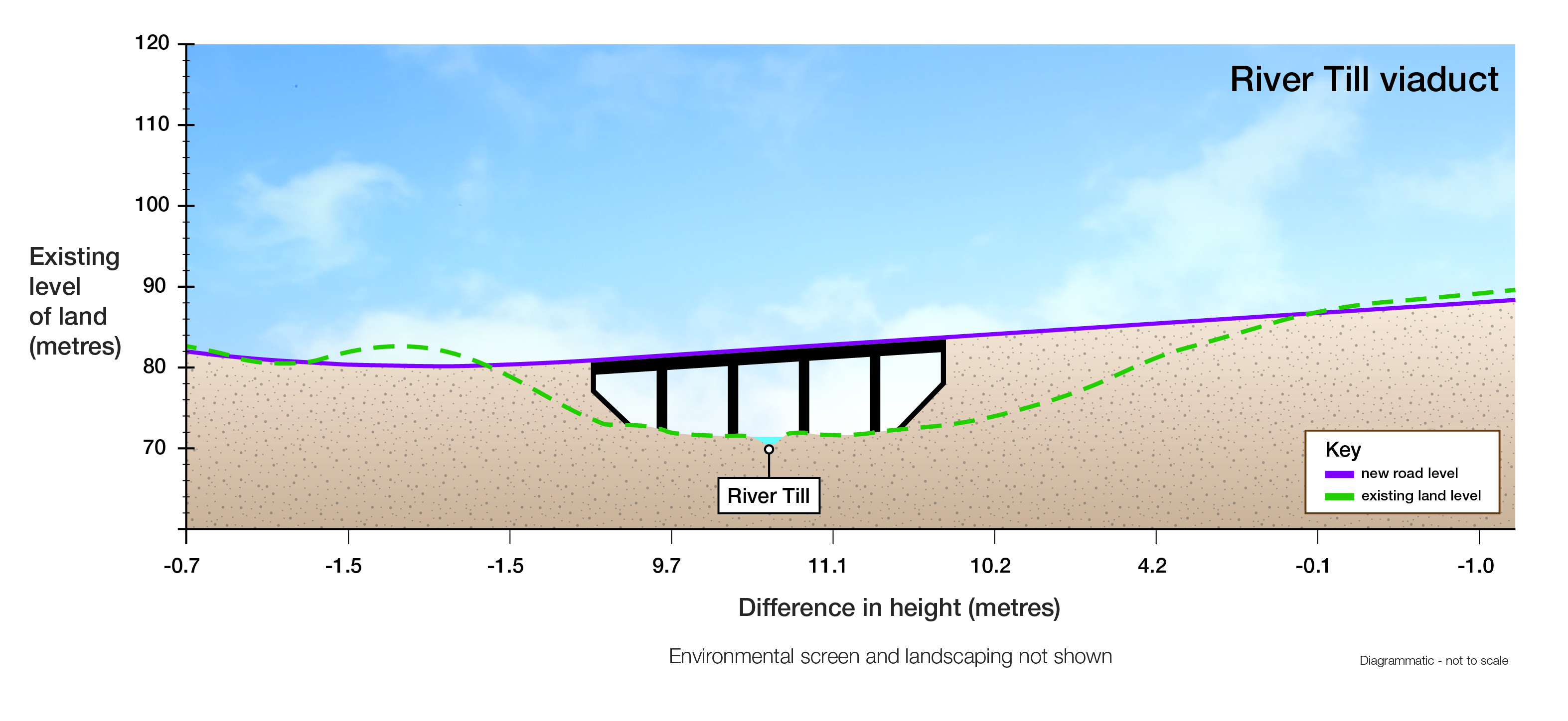
The new A303 will cross the River Till on a viaduct formed of two bridges side by side with a 7 metre gap in between. The viaduct will be approximately 210 metres long and around 10 metres high - measured from the river bank to the level of the new road (as seen in the diagram below).

There will be a 1.5 metre-high environmental barrier on the south side of the viaduct which will screen the majority of traffic and headlights from views from the valley floor to the south and northern edge of Winterbourne Stoke. The exact design, material and colour of the barrier has not yet been decided but will be selected to sympathetically blend into the landscape.
Why does the viaduct need to be so high?
When designing the viaduct, we considered many factors including how it looked in the landscape and importantly the impact on the local environment and farm traffic. These have influenced the height of the viaduct:
- The River Till is a Site of Special Scientific Interest and forms part of the River Avon Special Area of Conservation. The height and design of the viaduct with the gap between the carriageways will minimise the impact of shading from the new viaduct and allow sunlight down to the river and its banks.
- A local byway runs under the western span of the viaduct. We need to allow 5.3 metres headroom to allow agricultural vehicles and machinery safe access.
Why is the viaduct higher than in earlier schemes?
The maximum height of the viaduct proposed in 2003 was 7.4 metres which is lower than our proposed scheme. The design has changed slightly, but the primary reason for the difference is to reduce impact on environmentally protected areas, allowing for changes to environmental regulations since 2003. This includes making the gap between the bridges wider, as well as increasing the height.
The height of the viaduct has not been determined by the need to reuse material excavated from the tunnel. This is not suitable for the construction of structural highway embankments, all of the material will be used for specially designed landscaping.
Will there be a change in noise once the scheme is built?
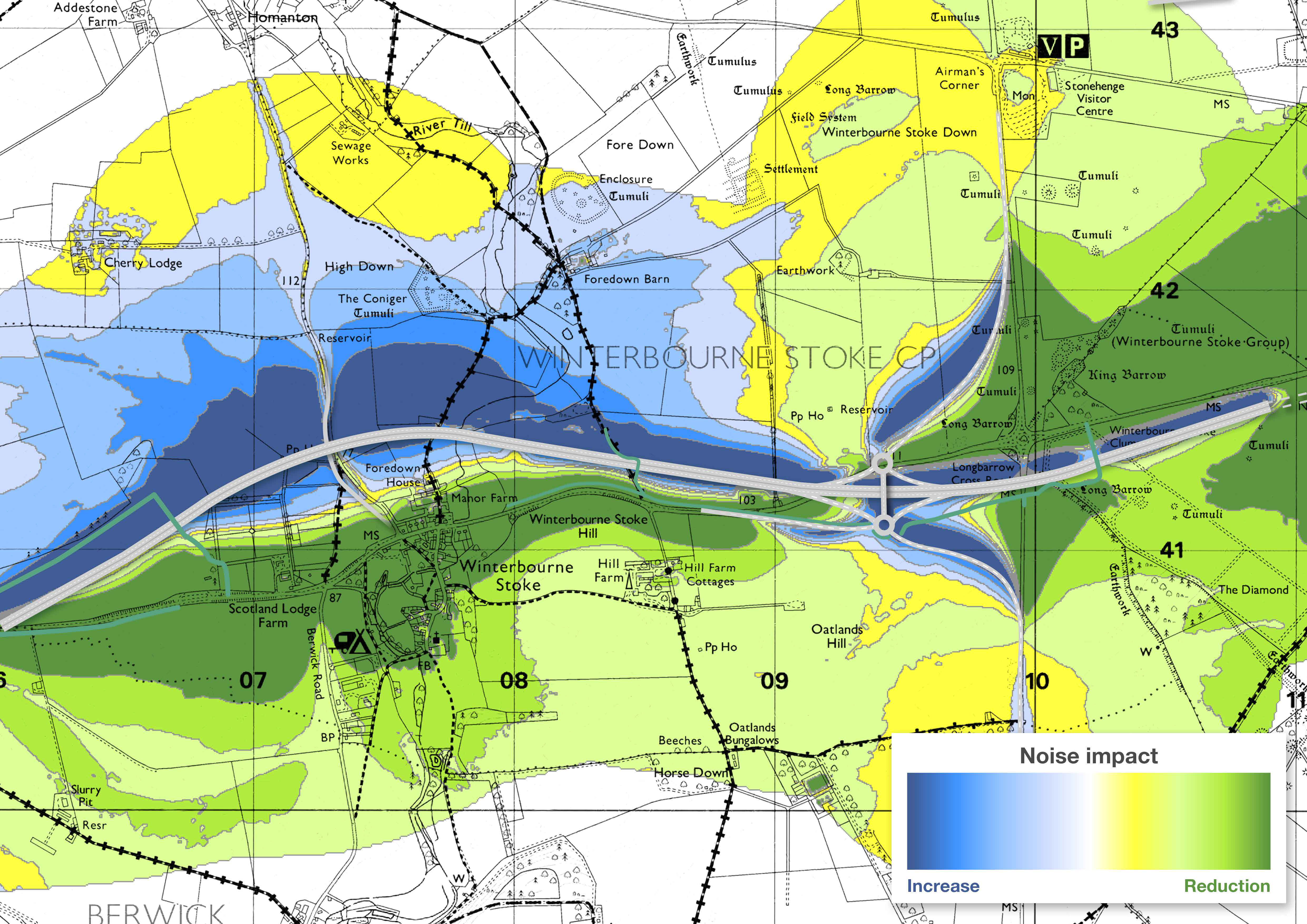
Winterbourne Stoke is currently badly affected by noise from vehicles on the existing A303 through the centre of the village. This is predicted to improve considerably with a major reduction in traffic and noise in the village with all bar one property (located on the northern edge of Winterbourne Stoke) experiencing lower noise levels.
From the closest houses immediately on the A303 traffic noise currently exceeds 70 decibels – this is predicted to fall to the high 50’s– low 60’s. To give an idea of what this could mean – a 10 decibels reduction would sound half as loud.
On the other hand, mainly unpopulated areas close to the new bypass will see an increase in traffic noise.

The environmental barrier on the River Till viaduct will help to reduce traffic noise levels to the south as well as the landscaping and positioning of the road in false cuttings.
We’re also planning to use ‘low noise’ surfacing for the new road which generates less noise than a ‘standard’ surface at higher traffic speeds.
