Walkers, cyclists and horse riders in Thurrock, Brentwood and Havering
Over 24 miles of new or improved pathways
In Thurrock, Brentwood, and Havering, we are creating new pathways and bridges, as well as improving existing pathways, to better connect the community to heritage areas, equestrian centres, places of employment, parks, and woodlands.
Four new green bridges will sit throughout this network of pathways, helping to connect the community to the area’s rich mosaic of parks and woodlands.
Some of the proposals in the Thurrock, Brentwood and Havering area are:
- Improved connections to heritage areas - between the local community and sites such as Coalhouse Fort and East Tilbury Battery
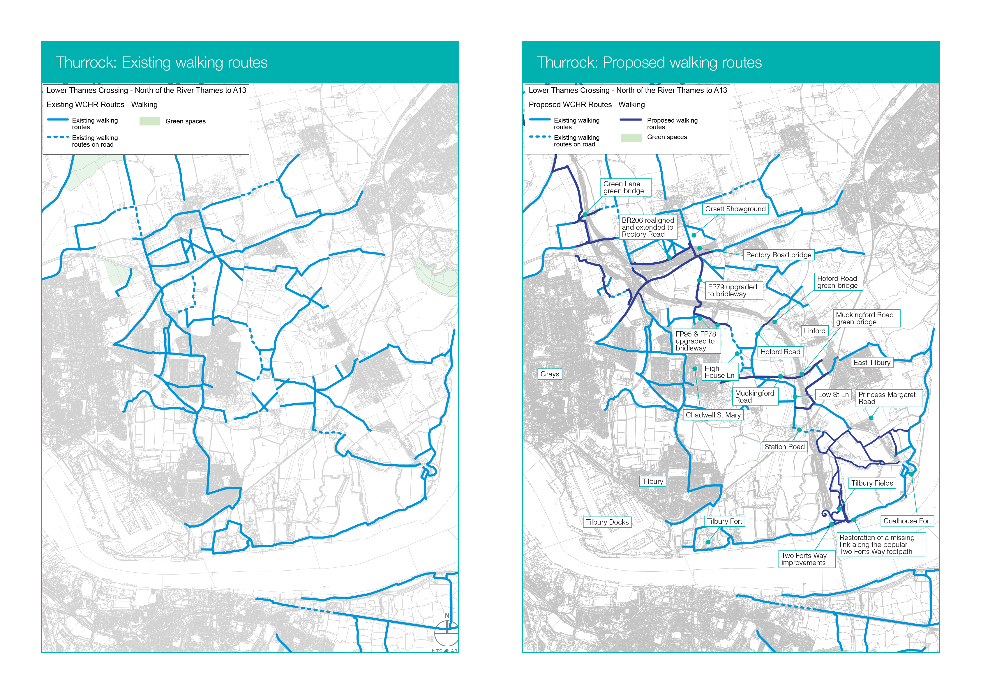
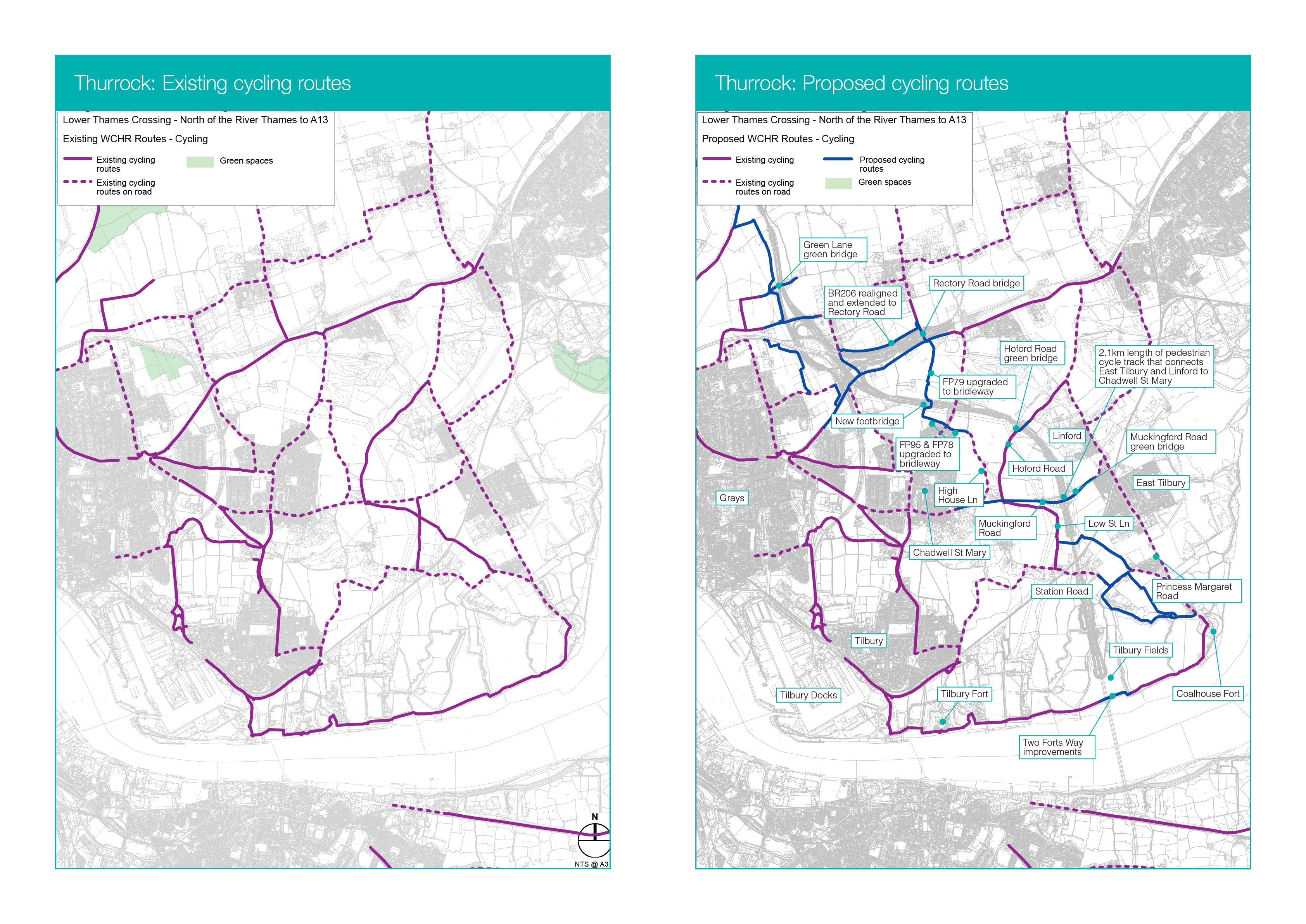
- A new 1.8 mile route - separated from road traffic, will provide a safer and easier way to commute by foot or bike between East Tilbury, Linford and Chadwell St Mary
- Two new footbridges over the A127 - to create safer, easier crossing points and restore links severed by the road over 100 years ago
- A footbridge and bridleway over the M25 - to complete an off-road route between a new community woodland on Hole Farm, Thames Chase Forest, and beyond
- Replacing Rectory Road bridge over the A13 - a wider bridge with a segregated horse track; resurfacing a nearby footpath to create a bridleway extending south
- Four new green bridges - will provide easier and safe crossing for people, horses and wildlife – seven in total along the proposed route
Some of the changes have been proposed following feedback received during our consultation in 2021.
Sign up to our newsletters to keep updated.
Watch our video
The new and improved pathways we’re delivering will help you make new journeys, whether you use the footpaths or travel by bike or horse.
Find out more about:
- Green bridges - safe and easy connections for people and wildlife
- Footpaths - creating new journeys
- Bridleways - an improved network for horse riders
- Cycle paths - improved and extended routes
Green bridges - safe and easy connections for people and wildlife
In total, seven new green bridges along the route will provide safe crossing places for people and wildlife, as well as blend the new structures into the landscape.
Four new green bridges will sit along the heart of this improved network of pathways in Thurrock, Brentwood, and Havering. These include the:
• North Road green bridge
• Green Lane green bridge
• Hoford Road green bridge
• Muckingford Road green bridge
Footpaths - creating new journeys
As well as creating new connections, we are going to restore some that have been lost in the past. When it was built almost 100 years ago, the A127 severed the link between Moor Lane and Folkes Lane, in the north-east of Upminster. To restore this link, we’re building a new footbridge that will give pedestrians and horse riders a new, safe crossing.
We are also creating a new footbridge that will span the M25 and better connect the two halves of the Thames Chase Community Forest.
A number of existing routes will also be upgraded and receive surface improvements to create better connectivity between Orsett and Chadwell St Mary.
These new pathways and the improvements to existing ones will give the community better access to the surrounding heritage areas, places of employment, parks, and woodlands
At Junction 29 of the M25, the project will change the existing slip roads between the A127 and M25 on the south side of the roundabout. These will become free-flowing slips, severing the southern footway along the south side of the A127. Users of this southern footway will no longer be able to pass between the east and west sides of the M25 Junction 29 without crossing to the north side of the roundabout. Additionally, it will become impossible for pedestrians to cross from north to south of the A127 at the roundabout.
To fix this severance, proposals include two new pedestrian-cycle bridges over the A127. The first bridge, located to the west of Junction 29, will link Folkes Lane in the north to Moor Lane in the south. To the east of the M25, another new pedestrian-cycle footbridge over the A127 will be created. Together, these two new footbridges will maintain east-west connectivity while reconnecting some of the historical severance caused by the A127.
The southern footway on the south of the A127 would be widened and improved. To help enhance an existing connection, these improvements will start from the BR186 crossing of the A127 in the east to the point at which it merges with bridleway BR189 in the west.
The BR189 bridleway will still cross the A127 at the existing bridge and it will still pass beneath the M25 adjacent the train line where it connects to FP176.
Where BR189 runs parallel to the M25 there will be surface improvements and localised diversions but the broader connectivity of BR189 will not be significantly impacted.
The FP79 footpath will be resurfaced to create a bridleway that extends further south of Rectory Road, creating a link from Rectory Road bridge to FP95. It will then be diverted via a new footbridge that crosses the project alignment.
To the south of the project alignment a new connection would be made to the FP95 footpath. From this point to Brentwood Road, the FP95 footpath would also be designated as bridleway and have its surface improved.
These changes would create an off-road equestrian connection and improve the pedestrian connectivity between Orsett and Chadwell St Mary.
To the east of Brentwood Road, High House Lane will be diverted south to join Brentwood Road at the South of the project alignment. This new alignment of High House Lane will clash with FP78.
The FP78 footpath will be diverted and upgraded to bridleway. This new diversion will run alongside the section of High House Lane which continues south past the western ends of FP64 and FP65, before meeting Muckingford Road.
We will be replacing the Rectory Road bridge over the A13 with a wider bridge that includes a segregated horse track. The existing shared pedestrian-cycle track would also be replaced with a wider track that sits parallel to the new horse track.
The existing BR206 bridleway would be diverted further north but remain parallel to the new slip road and A13. It will continue further east to meet Rectory Road where horse riders will be supplemented with a dedicated horse-riding track over the new bridge. The track will continue further south as far as a new crossing of Stanford Road A1013.
This allows horse riders to connect to the FP79 footpath, which will be resurfaced to create a bridleway that extends further south of Rectory Road. The FP79 footpath will then be diverted via a new footbridge that crosses the project alignment.
A 2.4km length of Stanford Road will be realigned because of the space required to form slip roads. Where Stanford Road is realigned, the existing shared pedestrian-cycle track that sits alongside Stanford Road will be replaced with one meeting current standards. This will terminate in the west adjacent Thurrock Rugby Football club where it will merge with the existing provision.
Between the junction with Stanford Road and the existing A13 bridge, Baker Street will be realigned. The existing footway to the east of this section of Baker Street will also be replaced with a wider shared ped-cycle route. This will maintain access to Stanford Road for those on Baker Street and create a new traffic free route alongside the part of Baker Street where vehicles travel fastest.
The distance between East Tilbury and the centre of Chadwell St Mary is 3km – a small enough distance to either walk or cycle. By introducing an off-road pedestrian-cycle track, communities from East Tilbury and Linford will be able to walk or cycle to the jobs and services available to them in Chadwell St Mary.
From the edge of East Tilbury, this new 2.1km length of off-road pedestrian cycle pathway would be alongside the south of Muckingford Road and Linford Road ending in Atherton Gardens in Chadwell St Mary.
As well as opening up access to jobs and services for those in East Tilbury and Linford this new route would provide an important link between existing routes used by NMUs. The new off-road route will link the ends of FP66, BR63, FP60, FP74, FP75, Hoford Road and High House Lane.
Muckingford Road to Coalhouse Fort
South of Muckingford Road the project alignment crosses the Tilbury Loop line, where it would be elevated on a viaduct to go over the Tilbury Loop Line and Station Road. To achieve the required clearance, the project rises onto an embankment south of Muckingford Road and returns to ground level south of Station Road.
The existing alignment of the BR58 bridleway would be severed by the embankment, north of the new viaduct. The western end of BR58 would therefore be diverted south to pass beneath the project’s new viaduct and connect to Low Street Lane in the west.
Connectivity between Muckingford Road and Coalhouse Fort would be maintained for cyclists and PRoW users through Low Street Lane - which is closed to motor traffic. Low Street Lane would allow users to connect with the BR63 bridleway or continue south to Station Road, maintaining the existing connectivity between Muckingford Road and Coalhouse Fort.
Station Road to Coalhouse Fort
The western end of the FP61 footpath would also be severed by the embankment north of the viaduct. Where this clash occurs, the FP61 pathway will be diverted south to meet the BR58 bridleway. Users of the FP61 pathway could either use BR58 to cross the rail line or come beneath the viaduct and use the Low Street Lane-BR63 route to head west.
The embankment and access road to the south of the viaduct clashes with the northern section of FP200. This section of the footpath would therefore be realigned along the new field edge to avoid this clash and maintain connectivity between Coalhouse Fort and Station Road.
East Tilbury to Coalhouse Fort and Bowater Batteries
New pathways will be created to link the heritage assets of Coalhouse Fort and Bowater Batteries to East Tilbury. This will create a variety of alternative paths along the coastal route of the River Thames and a footpath loop for visitors to Coalhouse Fort.
Funding improvements to the wider public rights of way network
We’re also funding improvements to the wider public rights of way network, including:
• The restoration of a missing link along the popular Two Forts Way footpath between Tilbury Fort and Coalhouse Fort that would be delivered by Thurrock Council.
• Supporting the Association of South Essex Local Authorities (ASELA) to improve the accessibility of the Coastal Path between Coalhouse Fort and Stanford-le-Hope
To make space for the Thames Freeport we are updating our designs for Tilbury Fields, which includes new routes connecting Two Forts Way to the existing network of public footpaths.
Have your say - a change has been proposed to this route following feedback received during our consultation in 2021. You will have the opportunity to give feedback on these and other changes in a consultation being planned later in the spring.
Bridleways – an improved network for horse riders
The Baker Street area is home to a number of well-known horse-riding facilities. To create easier and safer routes for horse riders accessing these facilities and the surrounding areas, we are building new bridleways and bridges, as well as improving those already there.
These improvements will enhance equestrian access to facilities like the Orsett Showground and provide easy and safe routes through areas such as the Thames Chase Community Forest, the Mardyke, and Little Belhus Country Park.
The Thames Chase Forest Centre is divided into east and west halves by the M25. A tunnel beneath the M25 currently provides the only access between the two halves of the Forest Centre.
While tracks and paths in the western half are available to horse riders and cyclists, the restricted headroom and difficult access to the tunnel means that cyclists and horse riders are excluded from the eastern half.
To enhance connectivity between the two sections of the Thames Chase, a new bridleway will be formed from the southern end of BR289 at the northern edge of the Forest Centre, to the visitor centre. This will replace an existing track that will be removed due to land acquisition required for the creation of new slip roads.
The visitor centre is linked to Ockendon Road to the south by the FP230 footpath, however the formation of new slip roads would sever this footpath. In order to maintain the connection to Ockendon Road and to form an improved connection between the two halves of the Forest Centre the project will re-route FP230 over a new footbridge spanning the M25.
The FP230 footpath will continue to the southeast corner of the eastern half of the Forest Centre. From here it will turn south along an existing access track to meet Ockendon Road, which is close to both the junction with Church Lane and eastbound and westbound bus stops.
FP230 will be designated as bridleway, providing a link between Ockendon Road and St Mary’s Lane through both halves of the Forest Centre and providing a traffic free cycle and equestrian route across the M25.
To further improve connectivity into Thames Chase a new bridleway connection will be formed from the eastern edge of the Forest Centre site to Clay Tye Road B186.
This will form a cycle link into the Forest Centre site from the housing on this part of Clay Tye Road but also improve access for those further afield along the B186.
For pedestrians, this will form a link between the housing on Clay Tye road but also to FP232 via a length of existing footway alongside Clay Tye Road.
Alongside Dennis Road there would be a new shared pedestrian, cycle and equestrian track from the Pea Lane/FP259 junction in the north to the Arisdale Avenue junction in the south.
This connection would create a link for pedestrians, cyclists and horse riders between South Ockendon, Little Belhus Park and the Thames Chase Community Forest.
The existing FP151 route would connect the new alignment of FP252 to North Road. The FP151 footpath would also be upgraded to bridleway and have its surface improved. From the point at which FP151 meets North Road there would be a shared pedestrian, cycle, equestrian track alongside North Road as far as Wilsman Road in South Ockendon. This would span the project alignment on a new green bridge and connect South Ockendon to FP135 and FP151.
These connections help form another link from South Ockendon to Thames Chase and open up a circular route involving Dennis Road.
The route alongside North Road would improve access to FP135 which runs from North Road in the west to Fen Lane in the east. From North Road to the point at which it turns north, FP135 would have its surface improved and be redesignated as bridleway. This improvement would end at a junction with existing farm track, and be designated as bridleway, forming a new PRoW link to FP136.
The part of FP136 to the east would remain unchanged and still provide pedestrian only access to the Mardyke. The FP136 pathway south of this point would be realigned over the project via a new bridge and be upgraded to bridleway, providing a new link to the Mardyke.
Cycle paths – improved and extended routes
Our plans to build new, and improve existing cycle paths, will make it easier than ever before to explore the surrounding area. This includes the rich network of woodlands and parks, as well as areas of work or places of education.
A length of the Mardyke Way BR219 bridleway will be upgraded to make its surface suitable for cyclists. In the north, these improvements start at the new bridge over the Mardyke. In the south, they will terminate at a new east-west section of bridleway into Orsett Fen. This bridleway will then turn in a north-south orientation and come parallel with the project alignment as far as Green Lane BR161 bridleway.
A short section of this bridleway will also be realigned where it would cross over a new area of water vole habitat to the east of the river. A bridge crossing would be provided.
The BR161 pathway will be realigned over a new bridge that crosses the project alignment with access to Baker Street. To the south of Green Lane, a new pedestrian-cycle track would connect both Green Lane and the new Mardyke route to Stifford Clays Road.
There is an existing pedestrian-cycle track alongside Stifford Clays Road from the edge of Stifford Clays in the west, extending close to Springfield farm in the east. This pedestrian-cycle track would be extended further east over the project alignment as far as the houses opposite Wayside Cottage.
This will allow pedestrians in the Baker Street area, or cyclists coming from Orsett, to access the Mardyke more easily and other Public Rights of Way. It will also allow pedestrians to reach employment and education opportunities as well as services in Stifford Clays. Equally it will improve access to the Mardyke for people in Stifford Clays.
The BR161 bridleway will be realigned over a new bridge crossing the project alignment with access to Baker Street, the stables and riding school.
The FP252 footpath would be diverted to a more southerly route to cross the rail line and the new project alignment on two new multi-user bridges. It would also be redesignated as bridleway and have its surface upgraded, making it suitable for all three user types.
